You are here: Home > Network List > TA - USArray Transportable Network (new EarthScope stations) Stations List
> Station G08A Pilot Rock, OR, USA > Earthquake Result Viewer
G08A Pilot Rock, OR, USA - Earthquake Result Viewer
| Earthquake location: |
Southeast Of Loyalty Islands |
| Earthquake latitude/longitude: |
-21.2/169.4 |
| Earthquake time(UTC): |
2007/09/28 (271) 01:01:48 GMT |
| Earthquake Depth: |
10 km |
| Earthquake Magnitude: |
5.8 MB, 6.4 MS, 6.3 MW, 6.2 MW |
| Earthquake Catalog/Contributor: |
WHDF/NEIC |
|
| Network: |
TA USArray Transportable Network (new EarthScope stations) |
| Station: |
G08A Pilot Rock, OR, USA |
| Lat/Lon: |
45.29 N/118.96 W |
| Elevation: |
1318 m |
|
| Distance: |
92.7 deg |
| Az: |
42.135 deg |
| Baz: |
242.476 deg |
| Ray Param: |
0.04140032 |
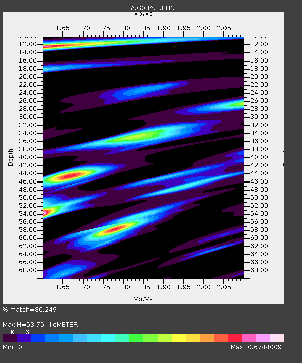
| Estimated Moho Depth: |
53.75 km |
| Estimated Crust Vp/Vs: |
1.60 |
| Assumed Crust Vp: |
6.571 km/s |
| Estimated Crust Vs: |
4.107 km/s |
| Estimated Crust Poisson's Ratio: |
0.18 |
|
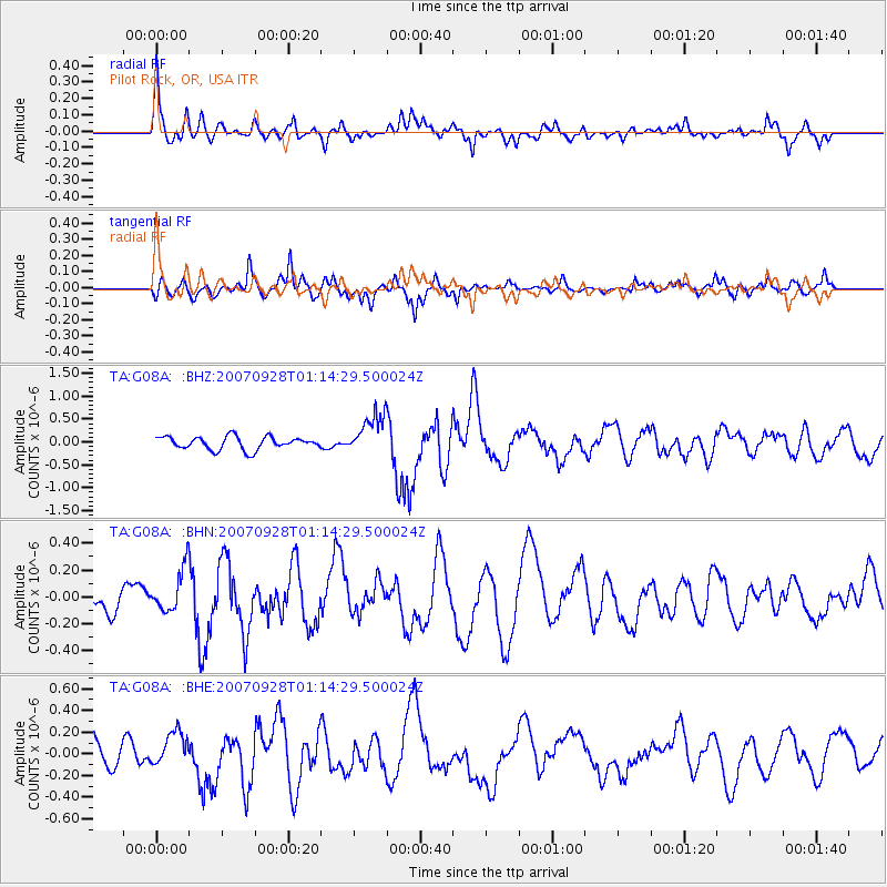
| Radial Match: |
80.249 % |
| Radial Bump: |
400 |
| Transverse Match: |
80.622215 % |
| Transverse Bump: |
379 |
| SOD ConfigId: |
2564 |
| Insert Time: |
2010-03-07 01:40:31.955 +0000 |
| GWidth: |
2.5 |
| Max Bumps: |
400 |
| Tol: |
0.001 |
|
Signal To Noise
| Channel | StoN | STA | LTA |
| TA:G08A: :BHN:20070928T01:14:29.500024Z | 1.5700768 | 1.653394E-7 | 1.0530657E-7 |
| TA:G08A: :BHE:20070928T01:14:29.500024Z | 1.297312 | 1.6419357E-7 | 1.2656443E-7 |
| TA:G08A: :BHZ:20070928T01:14:29.500024Z | 3.1861775 | 4.445201E-7 | 1.3951517E-7 |
| Arrivals |
| Ps | 5.0 SECOND |
| PpPs | 21 SECOND |
| PsPs/PpSs | 26 SECOND |


