You are here: Home > Network List > TA - USArray Transportable Network (new EarthScope stations) Stations List
> Station G08A Pilot Rock, OR, USA > Earthquake Result Viewer
G08A Pilot Rock, OR, USA - Earthquake Result Viewer

| Earthquake location: |
Southeast Of Loyalty Islands |
| Earthquake latitude/longitude: |
-21.1/169.3 |
| Earthquake time(UTC): |
2007/09/27 (270) 19:57:44 GMT |
| Earthquake Depth: |
9.0 km |
| Earthquake Magnitude: |
6.2 MB, 6.3 MS, 6.1 MW, 6.1 MW |
| Earthquake Catalog/Contributor: |
WHDF/NEIC |
|
| Network: |
TA USArray Transportable Network (new EarthScope stations) |
| Station: |
G08A Pilot Rock, OR, USA |
| Lat/Lon: |
45.29 N/118.96 W |
| Elevation: |
1318 m |
|
| Distance: |
92.7 deg |
| Az: |
42.157 deg |
| Baz: |
242.598 deg |
| Ray Param: |
0.041405983 |
| Estimated Moho Depth: |
33.75 km |
| Estimated Crust Vp/Vs: |
1.85 |
| Assumed Crust Vp: |
6.571 km/s |
| Estimated Crust Vs: |
3.547 km/s |
| Estimated Crust Poisson's Ratio: |
0.29 |
|
| Radial Match: |
84.45093 % |
| Radial Bump: |
353 |
| Transverse Match: |
69.81527 % |
| Transverse Bump: |
400 |
| SOD ConfigId: |
2564 |
| Insert Time: |
2010-03-07 01:40:34.193 +0000 |
| GWidth: |
2.5 |
| Max Bumps: |
400 |
| Tol: |
0.001 |
|
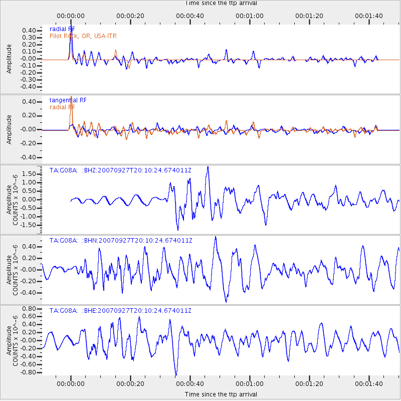
Signal To Noise
| Channel | StoN | STA | LTA |
| TA:G08A: :BHN:20070927T20:10:24.674011Z | 0.5347783 | 6.910342E-8 | 1.2921882E-7 |
| TA:G08A: :BHE:20070927T20:10:24.674011Z | 1.0677437 | 1.5585788E-7 | 1.4596937E-7 |
| TA:G08A: :BHZ:20070927T20:10:24.674011Z | 2.782935 | 4.290865E-7 | 1.5418487E-7 |
| Arrivals |
| Ps | 4.5 SECOND |
| PpPs | 14 SECOND |
| PsPs/PpSs | 19 SECOND |


