You are here: Home > Network List > PF - Volcanologic Network of Piton de Fournaise-OVPF Stations List
> Station CIL Cilaos (Pompiers) > Earthquake Result Viewer
CIL Cilaos (Pompiers) - Earthquake Result Viewer

| Earthquake location: |
New Ireland Region, P.N.G. |
| Earthquake latitude/longitude: |
-4.5/153.6 |
| Earthquake time(UTC): |
2016/12/17 (352) 10:51:11 GMT |
| Earthquake Depth: |
73 km |
| Earthquake Magnitude: |
8.0 Mi |
| Earthquake Catalog/Contributor: |
NEIC PDE/pt |
|
| Network: |
PF Volcanologic Network of Piton de Fournaise-OVPF |
| Station: |
CIL Cilaos (Pompiers) |
| Lat/Lon: |
21.13 S/55.47 E |
| Elevation: |
1223 m |
|
| Distance: |
95.9 deg |
| Az: |
248.312 deg |
| Baz: |
97.088 deg |
| Ray Param: |
0.040601067 |
| Estimated Moho Depth: |
11.25 km |
| Estimated Crust Vp/Vs: |
1.84 |
| Assumed Crust Vp: |
4.73 km/s |
| Estimated Crust Vs: |
2.574 km/s |
| Estimated Crust Poisson's Ratio: |
0.29 |
|
| Radial Match: |
80.38992 % |
| Radial Bump: |
400 |
| Transverse Match: |
62.921562 % |
| Transverse Bump: |
400 |
| SOD ConfigId: |
1894071 |
| Insert Time: |
2016-12-31 10:55:03.799 +0000 |
| GWidth: |
2.5 |
| Max Bumps: |
400 |
| Tol: |
0.001 |
|
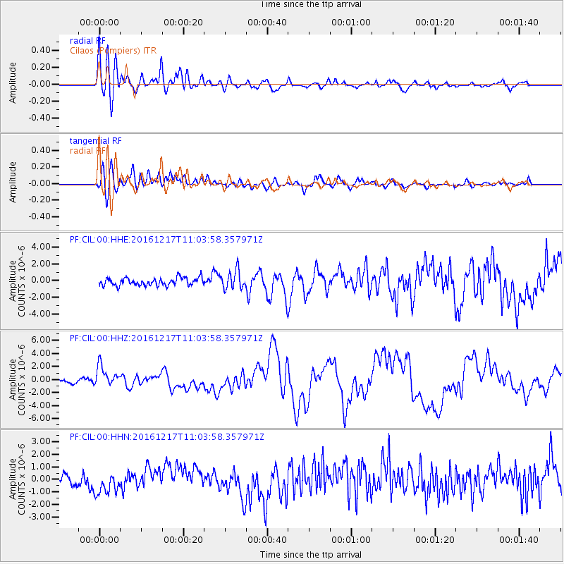
Signal To Noise
| Channel | StoN | STA | LTA |
| PF:CIL:00:HHZ:20161217T11:03:58.357971Z | 3.8273225 | 1.6705675E-6 | 4.3648464E-7 |
| PF:CIL:00:HHN:20161217T11:03:58.357971Z | 1.6585044 | 9.681952E-7 | 5.8377606E-7 |
| PF:CIL:00:HHE:20161217T11:03:58.357971Z | 2.414615 | 1.1087257E-6 | 4.5917287E-7 |
| Arrivals |
| Ps | 2.0 SECOND |
| PpPs | 6.7 SECOND |
| PsPs/PpSs | 8.7 SECOND |


