You are here: Home > Network List > TA - USArray Transportable Network (new EarthScope stations) Stations List
> Station G08A Pilot Rock, OR, USA > Earthquake Result Viewer
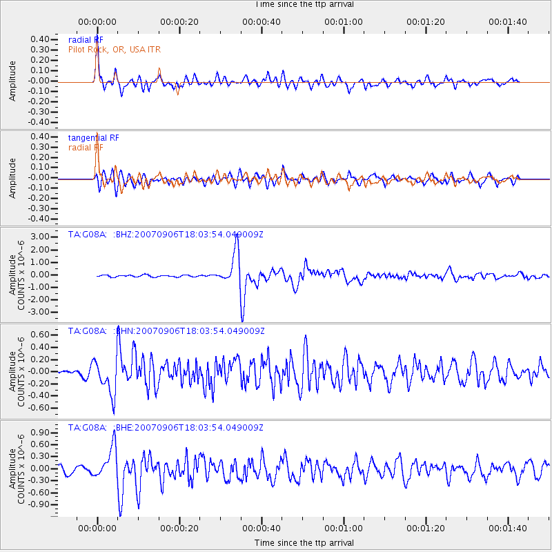
G08A Pilot Rock, OR, USA - Earthquake Result Viewer

| Earthquake location: |
Taiwan Region |
| Earthquake latitude/longitude: |
24.3/122.2 |
| Earthquake time(UTC): |
2007/09/06 (249) 17:51:26 GMT |
| Earthquake Depth: |
53 km |
| Earthquake Magnitude: |
6.1 MB, 6.2 MW, 6.1 ME |
| Earthquake Catalog/Contributor: |
WHDF/NEIC |
|
| Network: |
TA USArray Transportable Network (new EarthScope stations) |
| Station: |
G08A Pilot Rock, OR, USA |
| Lat/Lon: |
45.29 N/118.96 W |
| Elevation: |
1318 m |
|
| Distance: |
91.2 deg |
| Az: |
38.212 deg |
| Baz: |
306.935 deg |
| Ray Param: |
0.041613985 |
| Estimated Moho Depth: |
37.25 km |
| Estimated Crust Vp/Vs: |
1.78 |
| Assumed Crust Vp: |
6.571 km/s |
| Estimated Crust Vs: |
3.686 km/s |
| Estimated Crust Poisson's Ratio: |
0.27 |
|
| Radial Match: |
87.27965 % |
| Radial Bump: |
400 |
| Transverse Match: |
76.78257 % |
| Transverse Bump: |
400 |
| SOD ConfigId: |
2564 |
| Insert Time: |
2010-03-07 01:40:38.557 +0000 |
| GWidth: |
2.5 |
| Max Bumps: |
400 |
| Tol: |
0.001 |
|
Signal To Noise
| Channel | StoN | STA | LTA |
| TA:G08A: :BHN:20070906T18:03:54.049009Z | 5.626345 | 2.9533828E-7 | 5.249203E-8 |
| TA:G08A: :BHE:20070906T18:03:54.049009Z | 5.0885983 | 4.108551E-7 | 8.074033E-8 |
| TA:G08A: :BHZ:20070906T18:03:54.049009Z | 18.160496 | 1.3532971E-6 | 7.4518724E-8 |
| Arrivals |
| Ps | 4.5 SECOND |
| PpPs | 15 SECOND |
| PsPs/PpSs | 20 SECOND |


