You are here: Home > Network List > PF - Volcanologic Network of Piton de Fournaise-OVPF Stations List
> Station FLR Station Sismologique de Flanc Est > Earthquake Result Viewer
FLR Station Sismologique de Flanc Est - Earthquake Result Viewer
| Earthquake location: |
New Ireland Region, P.N.G. |
| Earthquake latitude/longitude: |
-4.5/153.6 |
| Earthquake time(UTC): |
2016/12/17 (352) 10:51:11 GMT |
| Earthquake Depth: |
73 km |
| Earthquake Magnitude: |
8.0 Mi |
| Earthquake Catalog/Contributor: |
NEIC PDE/pt |
|
| Network: |
PF Volcanologic Network of Piton de Fournaise-OVPF |
| Station: |
FLR Station Sismologique de Flanc Est |
| Lat/Lon: |
21.24 S/55.73 E |
| Elevation: |
1947 m |
|
| Distance: |
95.7 deg |
| Az: |
248.236 deg |
| Baz: |
97.001 deg |
| Ray Param: |
0.04066919 |
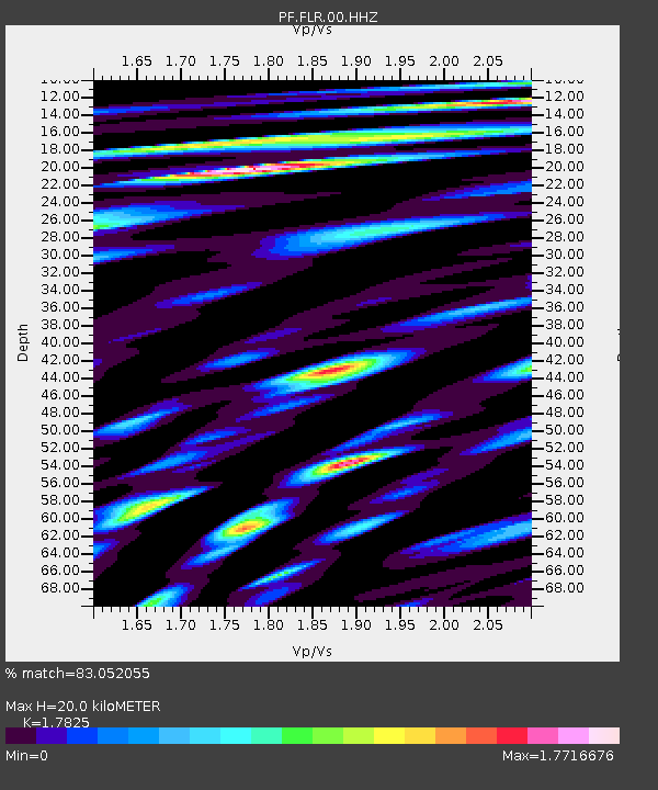
| Estimated Moho Depth: |
20.0 km |
| Estimated Crust Vp/Vs: |
1.78 |
| Assumed Crust Vp: |
4.73 km/s |
| Estimated Crust Vs: |
2.654 km/s |
| Estimated Crust Poisson's Ratio: |
0.27 |
|
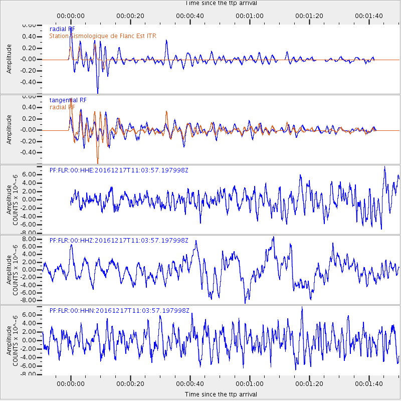
| Radial Match: |
83.052055 % |
| Radial Bump: |
400 |
| Transverse Match: |
73.35201 % |
| Transverse Bump: |
400 |
| SOD ConfigId: |
1894071 |
| Insert Time: |
2016-12-31 10:55:06.972 +0000 |
| GWidth: |
2.5 |
| Max Bumps: |
400 |
| Tol: |
0.001 |
|
Signal To Noise
| Channel | StoN | STA | LTA |
| PF:FLR:00:HHZ:20161217T11:03:57.197998Z | 2.4007664 | 3.0927004E-6 | 1.2882139E-6 |
| PF:FLR:00:HHN:20161217T11:03:57.197998Z | 1.1026268 | 1.8216853E-6 | 1.6521323E-6 |
| PF:FLR:00:HHE:20161217T11:03:57.197998Z | 1.0854816 | 1.356188E-6 | 1.2493882E-6 |
| Arrivals |
| Ps | 3.3 SECOND |
| PpPs | 12 SECOND |
| PsPs/PpSs | 15 SECOND |


