You are here: Home > Network List > TA - USArray Transportable Network (new EarthScope stations) Stations List
> Station G08A Pilot Rock, OR, USA > Earthquake Result Viewer
G08A Pilot Rock, OR, USA - Earthquake Result Viewer
| Earthquake location: |
Solomon Islands |
| Earthquake latitude/longitude: |
-9.8/159.5 |
| Earthquake time(UTC): |
2007/08/16 (228) 08:39:27 GMT |
| Earthquake Depth: |
10 km |
| Earthquake Magnitude: |
6.1 MB, 6.7 MS, 6.4 MW |
| Earthquake Catalog/Contributor: |
WHDF/NEIC |
|
| Network: |
TA USArray Transportable Network (new EarthScope stations) |
| Station: |
G08A Pilot Rock, OR, USA |
| Lat/Lon: |
45.29 N/118.96 W |
| Elevation: |
1318 m |
|
| Distance: |
91.0 deg |
| Az: |
44.298 deg |
| Baz: |
257.17 deg |
| Ray Param: |
0.041630246 |
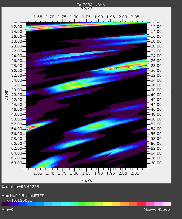
| Estimated Moho Depth: |
12.5 km |
| Estimated Crust Vp/Vs: |
1.61 |
| Assumed Crust Vp: |
6.571 km/s |
| Estimated Crust Vs: |
4.075 km/s |
| Estimated Crust Poisson's Ratio: |
0.19 |
|
| Radial Match: |
96.62258 % |
| Radial Bump: |
311 |
| Transverse Match: |
91.59602 % |
| Transverse Bump: |
400 |
| SOD ConfigId: |
2564 |
| Insert Time: |
2010-03-07 01:40:49.090 +0000 |
| GWidth: |
2.5 |
| Max Bumps: |
400 |
| Tol: |
0.001 |
|
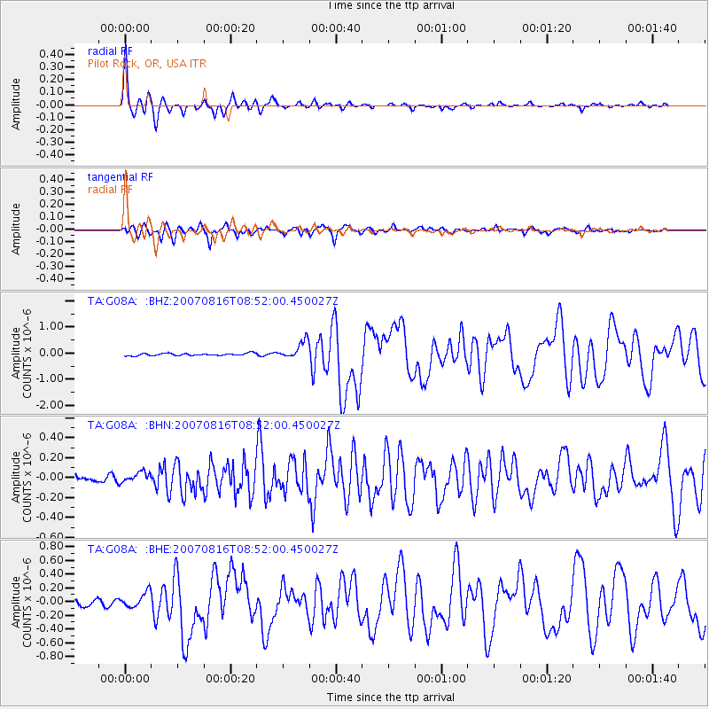
Signal To Noise
| Channel | StoN | STA | LTA |
| TA:G08A: :BHN:20070816T08:52:00.450027Z | 1.4285283 | 4.6598124E-8 | 3.261967E-8 |
| TA:G08A: :BHE:20070816T08:52:00.450027Z | 2.4005866 | 1.08774756E-7 | 4.531174E-8 |
| TA:G08A: :BHZ:20070816T08:52:00.450027Z | 7.929399 | 3.410391E-7 | 4.300945E-8 |
| Arrivals |
| Ps | 1.2 SECOND |
| PpPs | 4.9 SECOND |
| PsPs/PpSs | 6.0 SECOND |


