G08A Pilot Rock, OR, USA - Earthquake Result Viewer
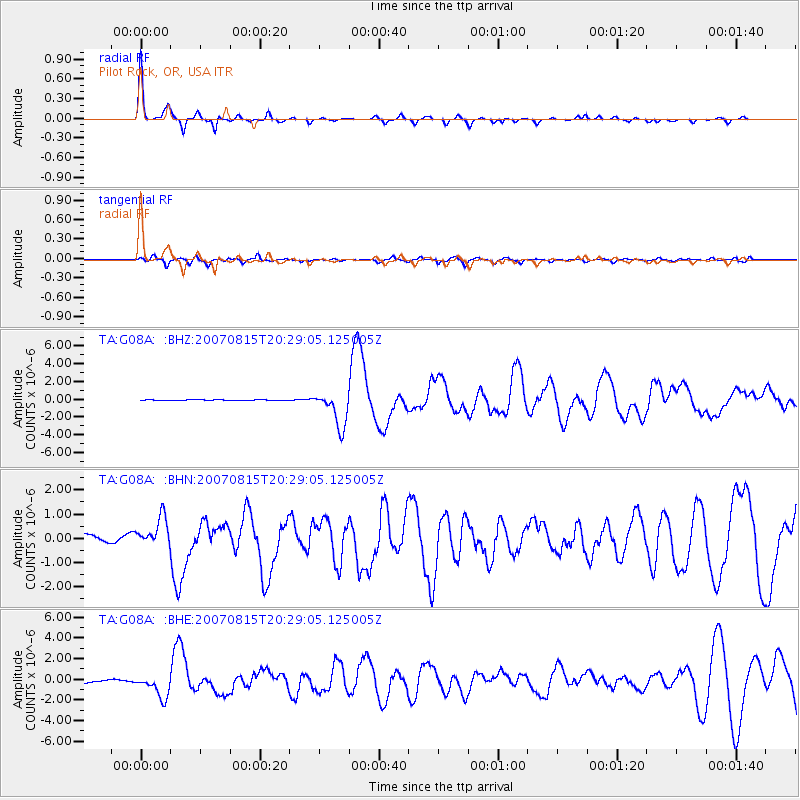
Earthquake location: Andreanof Islands, Aleutian Is.
Earthquake latitude/longitude: 50.3/-177.5
Earthquake time(UTC): 2007/08/15 (227) 20:22:11 GMT
Earthquake Depth: 9.0 km
Earthquake Magnitude: 6.3 MB, 6.2 MS, 6.4 MW, 5.9 ML
Earthquake Catalog/Contributor: WHDF/NEIC
Network: TA USArray Transportable Network (new EarthScope stations)
Station: G08A Pilot Rock, OR, USA
Lat/Lon: 45.29 N/118.96 W
Elevation: 1318 m
Distance: 38.8 deg
Az: 74.095 deg
Baz: 299.153 deg
Ray Param: 0.07536292
Estimated Moho Depth: 25.25 km
Estimated Crust Vp/Vs: 1.71
Assumed Crust Vp: 6.571 km/s
Estimated Crust Vs: 3.848 km/s
Estimated Crust Poisson's Ratio: 0.24
Radial Match: 90.757515 %
Radial Bump: 284
Transverse Match: 76.543274 %
Transverse Bump: 400
SOD ConfigId: 2564
Insert Time: 2010-03-07 01:40:53.953 +0000
GWidth: 2.5
Max Bumps: 400
Tol: 0.001

Signal To Noise

ChannelStoNSTALTA
TA:G08A: :BHN:20070815T20:29:05.125005Z3.63839866.204637E-71.7053209E-7
TA:G08A: :BHE:20070815T20:29:05.125005Z6.78525731.104834E-61.6282861E-7
TA:G08A: :BHZ:20070815T20:29:05.125005Z38.6821172.0247583E-65.234352E-8
Arrivals
Ps2.9 SECOND
PpPs9.6 SECOND
PsPs/PpSs13 SECOND