You are here: Home > Network List > TA - USArray Transportable Network (new EarthScope stations) Stations List
> Station G08A Pilot Rock, OR, USA > Earthquake Result Viewer
G08A Pilot Rock, OR, USA - Earthquake Result Viewer

| Earthquake location: |
Southeast Of Loyalty Islands |
| Earthquake latitude/longitude: |
-21.5/170.9 |
| Earthquake time(UTC): |
2007/07/27 (208) 14:46:26 GMT |
| Earthquake Depth: |
10 km |
| Earthquake Magnitude: |
6.0 MB, 6.0 MS, 6.1 MW, 6.1 MW |
| Earthquake Catalog/Contributor: |
WHDF/NEIC |
|
| Network: |
TA USArray Transportable Network (new EarthScope stations) |
| Station: |
G08A Pilot Rock, OR, USA |
| Lat/Lon: |
45.29 N/118.96 W |
| Elevation: |
1318 m |
|
| Distance: |
91.9 deg |
| Az: |
41.616 deg |
| Baz: |
241.211 deg |
| Ray Param: |
0.04153393 |
| Estimated Moho Depth: |
35.5 km |
| Estimated Crust Vp/Vs: |
1.81 |
| Assumed Crust Vp: |
6.571 km/s |
| Estimated Crust Vs: |
3.63 km/s |
| Estimated Crust Poisson's Ratio: |
0.28 |
|
| Radial Match: |
86.534645 % |
| Radial Bump: |
304 |
| Transverse Match: |
81.34321 % |
| Transverse Bump: |
396 |
| SOD ConfigId: |
2564 |
| Insert Time: |
2010-03-07 01:41:00.866 +0000 |
| GWidth: |
2.5 |
| Max Bumps: |
400 |
| Tol: |
0.001 |
|
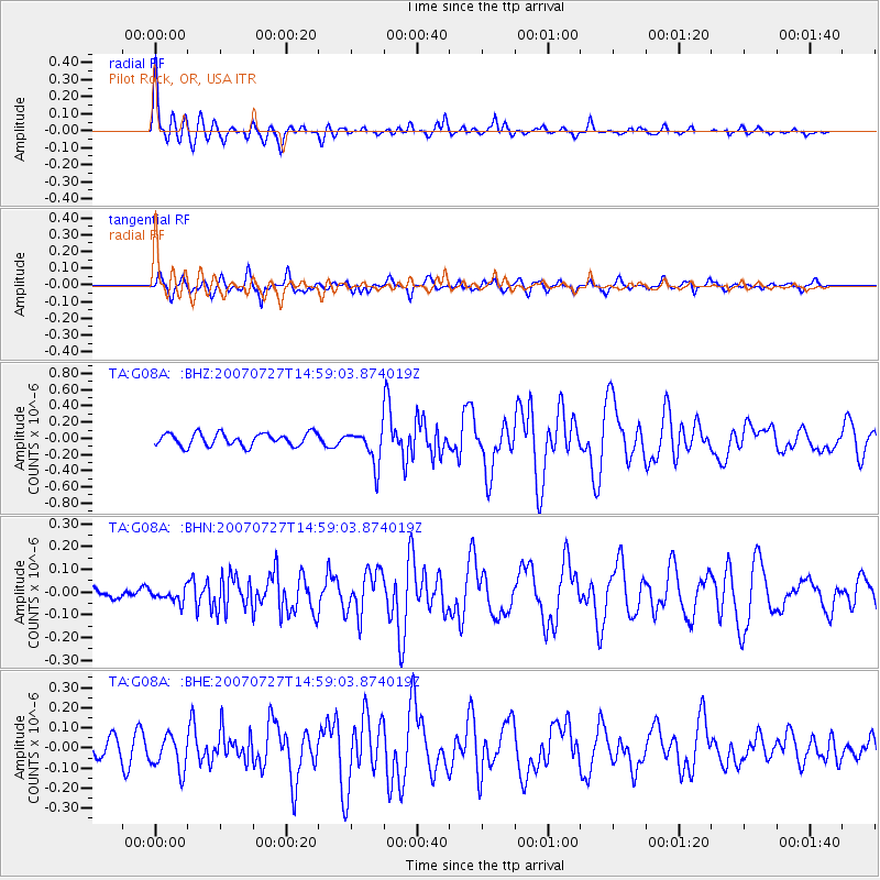
Signal To Noise
| Channel | StoN | STA | LTA |
| TA:G08A: :BHN:20070727T14:59:03.874019Z | 1.0076579 | 2.8311069E-8 | 2.8095913E-8 |
| TA:G08A: :BHE:20070727T14:59:03.874019Z | 1.8858083 | 8.723965E-8 | 4.626114E-8 |
| TA:G08A: :BHZ:20070727T14:59:03.874019Z | 2.8008168 | 2.185714E-7 | 7.8038454E-8 |
| Arrivals |
| Ps | 4.5 SECOND |
| PpPs | 15 SECOND |
| PsPs/PpSs | 19 SECOND |


