You are here: Home > Network List > PF - Volcanologic Network of Piton de Fournaise-OVPF Stations List
> Station HIM cratere Himiltrude > Earthquake Result Viewer
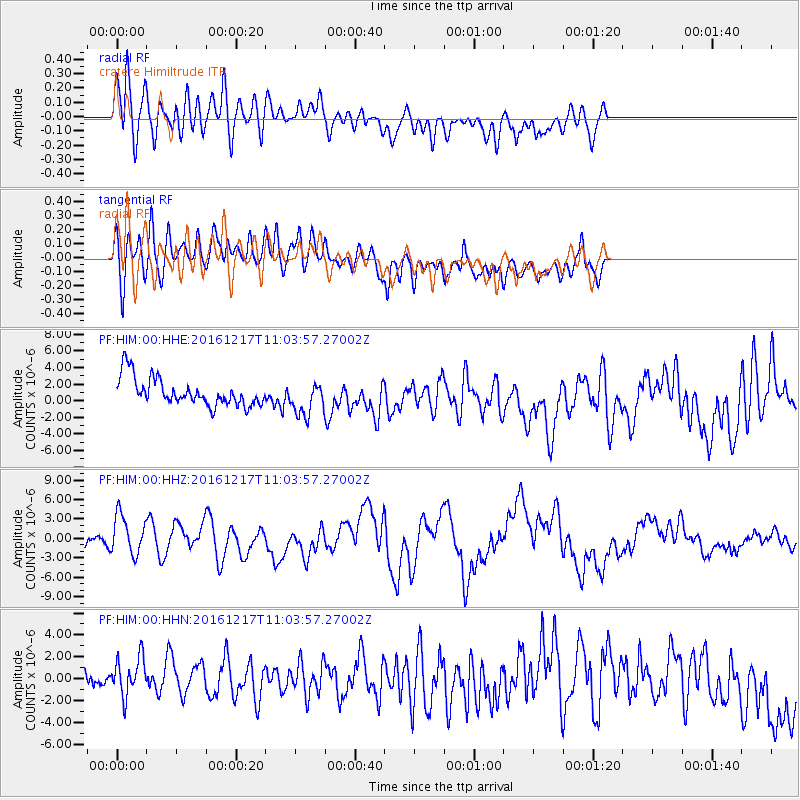
HIM cratere Himiltrude - Earthquake Result Viewer
*The percent match for this event was below the threshold and hence no stack was calculated.
| Earthquake location: |
New Ireland Region, P.N.G. |
| Earthquake latitude/longitude: |
-4.5/153.6 |
| Earthquake time(UTC): |
2016/12/17 (352) 10:51:11 GMT |
| Earthquake Depth: |
73 km |
| Earthquake Magnitude: |
8.0 Mi |
| Earthquake Catalog/Contributor: |
NEIC PDE/pt |
|
| Network: |
PF Volcanologic Network of Piton de Fournaise-OVPF |
| Station: |
HIM cratere Himiltrude |
| Lat/Lon: |
21.21 S/55.72 E |
| Elevation: |
1958 m |
|
| Distance: |
95.7 deg |
| Az: |
248.264 deg |
| Baz: |
97.003 deg |
| Ray Param: |
$rayparam |
*The percent match for this event was below the threshold and hence was not used in the summary stack. |
|
| Radial Match: |
70.39157 % |
| Radial Bump: |
400 |
| Transverse Match: |
68.963615 % |
| Transverse Bump: |
400 |
| SOD ConfigId: |
1894071 |
| Insert Time: |
2016-12-31 10:55:13.381 +0000 |
| GWidth: |
2.5 |
| Max Bumps: |
400 |
| Tol: |
0.001 |
|
Signal To Noise
| Channel | StoN | STA | LTA |
| PF:HIM:00:HHZ:20161217T11:03:57.27002Z | 2.4284482 | 3.0828921E-6 | 1.2694906E-6 |
| PF:HIM:00:HHN:20161217T11:03:57.27002Z | 1.2257521 | 2.5558318E-6 | 2.085113E-6 |
| PF:HIM:00:HHE:20161217T11:03:57.27002Z | 1.1996627 | 2.0205043E-6 | 1.6842271E-6 |
| Arrivals |
| Ps | |
| PpPs | |
| PsPs/PpSs | |


