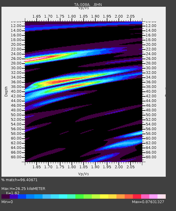
G08A Pilot Rock, OR, USA - Earthquake Result Viewer

Earthquake location: Near West Coast Of Honshu, Japan
Earthquake latitude/longitude: 37.5/138.4
Earthquake time(UTC): 2007/07/16 (197) 01:13:22 GMT
Earthquake Depth: 12 km
Earthquake Magnitude: 6.5 MB, 6.4 MS, 6.6 MW, 6.5 MW
Earthquake Catalog/Contributor: WHDF/NEIC
Network: TA USArray Transportable Network (new EarthScope stations)
Station: G08A Pilot Rock, OR, USA
Lat/Lon: 45.29 N/118.96 W
Elevation: 1318 m
Distance: 72.1 deg
Az: 46.382 deg
Baz: 305.384 deg
Ray Param: 0.053881768
Estimated Moho Depth: 26.25 km
Estimated Crust Vp/Vs: 1.62
Assumed Crust Vp: 6.571 km/s
Estimated Crust Vs: 4.056 km/s
Estimated Crust Poisson's Ratio: 0.19
Radial Match: 96.40671 %
Radial Bump: 347
Transverse Match: 90.108345 %
Transverse Bump: 400
SOD ConfigId: 2564
Insert Time: 2010-03-07 01:41:05.457 +0000
GWidth: 2.5
Max Bumps: 400
Tol: 0.001

Signal To Noise

ChannelStoNSTALTA
TA:G08A: :BHN:20070716T01:24:15.174016Z11.6228635.341189E-74.595416E-8
TA:G08A: :BHE:20070716T01:24:15.174016Z24.4313457.2073294E-72.9500338E-8
TA:G08A: :BHZ:20070716T01:24:15.174016Z22.2509171.8730711E-68.41795E-8
Arrivals
Ps2.6 SECOND
PpPs10 SECOND
PsPs/PpSs13 SECOND