You are here: Home > Network List > TA - USArray Transportable Network (new EarthScope stations) Stations List
> Station A19K Wainwright, AK, USA > Earthquake Result Viewer
A19K Wainwright, AK, USA - Earthquake Result Viewer
| Earthquake location: |
Northwest Of Ryukyu Islands |
| Earthquake latitude/longitude: |
29.4/128.2 |
| Earthquake time(UTC): |
2019/07/13 (194) 00:57:44 GMT |
| Earthquake Depth: |
251 km |
| Earthquake Magnitude: |
6.1 Mww |
| Earthquake Catalog/Contributor: |
NEIC PDE/us |
|
| Network: |
TA USArray Transportable Network (new EarthScope stations) |
| Station: |
A19K Wainwright, AK, USA |
| Lat/Lon: |
70.20 N/161.07 W |
| Elevation: |
24 m |
|
| Distance: |
56.2 deg |
| Az: |
22.778 deg |
| Baz: |
262.802 deg |
| Ray Param: |
0.063432805 |
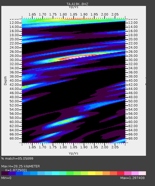
| Estimated Moho Depth: |
28.25 km |
| Estimated Crust Vp/Vs: |
1.87 |
| Assumed Crust Vp: |
5.989 km/s |
| Estimated Crust Vs: |
3.198 km/s |
| Estimated Crust Poisson's Ratio: |
0.30 |
|
| Radial Match: |
85.05899 % |
| Radial Bump: |
400 |
| Transverse Match: |
72.06723 % |
| Transverse Bump: |
400 |
| SOD ConfigId: |
19053131 |
| Insert Time: |
2019-07-27 01:06:00.650 +0000 |
| GWidth: |
2.5 |
| Max Bumps: |
400 |
| Tol: |
0.001 |
|

Signal To Noise
| Channel | StoN | STA | LTA |
| TA:A19K: :BHZ:20190713T01:06:27.524974Z | 14.832152 | 2.3941761E-6 | 1.6141799E-7 |
| TA:A19K: :BHN:20190713T01:06:27.524974Z | 2.2398965 | 1.8851551E-7 | 8.41626E-8 |
| TA:A19K: :BHE:20190713T01:06:27.524974Z | 5.000172 | 6.9337614E-7 | 1.3867046E-7 |
| Arrivals |
| Ps | 4.3 SECOND |
| PpPs | 13 SECOND |
| PsPs/PpSs | 17 SECOND |


