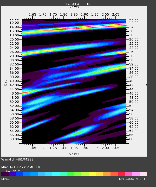
G08A Pilot Rock, OR, USA - Earthquake Result Viewer
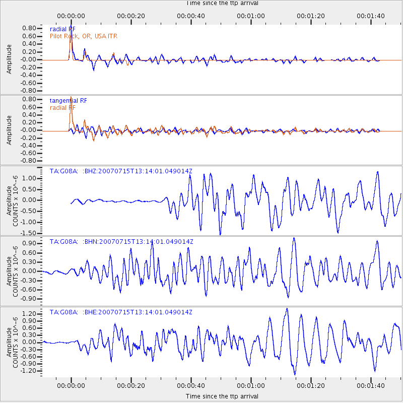
Earthquake location: Fox Islands, Aleutian Islands
Earthquake latitude/longitude: 52.5/-168.0
Earthquake time(UTC): 2007/07/15 (196) 13:08:00 GMT
Earthquake Depth: 10 km
Earthquake Magnitude: 5.8 MB, 5.9 MS, 6.1 MW, 6.0 MW
Earthquake Catalog/Contributor: WHDF/NEIC
Network: TA USArray Transportable Network (new EarthScope stations)
Station: G08A Pilot Rock, OR, USA
Lat/Lon: 45.29 N/118.96 W
Elevation: 1318 m
Distance: 32.5 deg
Az: 82.791 deg
Baz: 300.728 deg
Ray Param: 0.078613676
Estimated Moho Depth: 13.25 km
Estimated Crust Vp/Vs: 2.00
Assumed Crust Vp: 6.571 km/s
Estimated Crust Vs: 3.289 km/s
Estimated Crust Poisson's Ratio: 0.33
Radial Match: 80.94228 %
Radial Bump: 297
Transverse Match: 72.49249 %
Transverse Bump: 400
SOD ConfigId: 2564
Insert Time: 2010-03-07 01:41:08.772 +0000
GWidth: 2.5
Max Bumps: 400
Tol: 0.001

Signal To Noise

ChannelStoNSTALTA
TA:G08A: :BHN:20070715T13:14:01.049014Z1.85475168.6124224E-84.643437E-8
TA:G08A: :BHE:20070715T13:14:01.049014Z3.89421631.2655961E-73.2499376E-8
TA:G08A: :BHZ:20070715T13:14:01.049014Z4.50686172.1916871E-74.8630007E-8
Arrivals
Ps2.2 SECOND
PpPs5.6 SECOND
PsPs/PpSs7.8 SECOND