You are here: Home > Network List > TA - USArray Transportable Network (new EarthScope stations) Stations List
> Station B18K Kokolik River, AK, USA > Earthquake Result Viewer
B18K Kokolik River, AK, USA - Earthquake Result Viewer
| Earthquake location: |
Northwest Of Ryukyu Islands |
| Earthquake latitude/longitude: |
29.4/128.2 |
| Earthquake time(UTC): |
2019/07/13 (194) 00:57:44 GMT |
| Earthquake Depth: |
251 km |
| Earthquake Magnitude: |
6.1 Mww |
| Earthquake Catalog/Contributor: |
NEIC PDE/us |
|
| Network: |
TA USArray Transportable Network (new EarthScope stations) |
| Station: |
B18K Kokolik River, AK, USA |
| Lat/Lon: |
69.36 N/161.80 W |
| Elevation: |
222 m |
|
| Distance: |
55.8 deg |
| Az: |
23.75 deg |
| Baz: |
262.66 deg |
| Ray Param: |
0.06365721 |
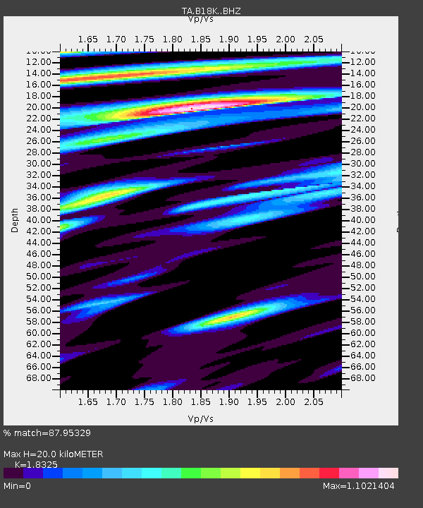
| Estimated Moho Depth: |
20.0 km |
| Estimated Crust Vp/Vs: |
1.83 |
| Assumed Crust Vp: |
5.906 km/s |
| Estimated Crust Vs: |
3.223 km/s |
| Estimated Crust Poisson's Ratio: |
0.29 |
|
| Radial Match: |
87.95329 % |
| Radial Bump: |
400 |
| Transverse Match: |
77.40352 % |
| Transverse Bump: |
400 |
| SOD ConfigId: |
19053131 |
| Insert Time: |
2019-07-27 01:06:02.873 +0000 |
| GWidth: |
2.5 |
| Max Bumps: |
400 |
| Tol: |
0.001 |
|
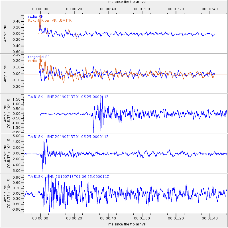
Signal To Noise
| Channel | StoN | STA | LTA |
| TA:B18K: :BHZ:20190713T01:06:25.000011Z | 26.64326 | 2.5113998E-6 | 9.426023E-8 |
| TA:B18K: :BHN:20190713T01:06:25.000011Z | 4.770717 | 3.2667802E-7 | 6.8475664E-8 |
| TA:B18K: :BHE:20190713T01:06:25.000011Z | 12.088601 | 5.8573505E-7 | 4.84535E-8 |
| Arrivals |
| Ps | 2.9 SECOND |
| PpPs | 9.2 SECOND |
| PsPs/PpSs | 12 SECOND |


