You are here: Home > Network List > TA - USArray Transportable Network (new EarthScope stations) Stations List
> Station C18K Utukok River, AK, USA > Earthquake Result Viewer
C18K Utukok River, AK, USA - Earthquake Result Viewer
| Earthquake location: |
Northwest Of Ryukyu Islands |
| Earthquake latitude/longitude: |
29.4/128.2 |
| Earthquake time(UTC): |
2019/07/13 (194) 00:57:44 GMT |
| Earthquake Depth: |
251 km |
| Earthquake Magnitude: |
6.1 Mww |
| Earthquake Catalog/Contributor: |
NEIC PDE/us |
|
| Network: |
TA USArray Transportable Network (new EarthScope stations) |
| Station: |
C18K Utukok River, AK, USA |
| Lat/Lon: |
68.65 N/161.19 W |
| Elevation: |
845 m |
|
| Distance: |
56.0 deg |
| Az: |
24.644 deg |
| Baz: |
263.728 deg |
| Ray Param: |
0.06357453 |
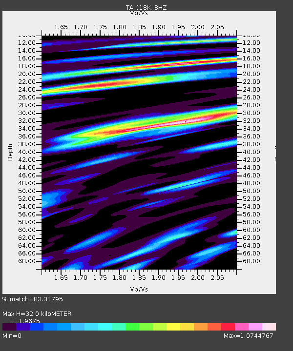
| Estimated Moho Depth: |
32.0 km |
| Estimated Crust Vp/Vs: |
1.97 |
| Assumed Crust Vp: |
5.906 km/s |
| Estimated Crust Vs: |
3.002 km/s |
| Estimated Crust Poisson's Ratio: |
0.33 |
|
| Radial Match: |
83.31795 % |
| Radial Bump: |
400 |
| Transverse Match: |
77.82261 % |
| Transverse Bump: |
400 |
| SOD ConfigId: |
19053131 |
| Insert Time: |
2019-07-27 01:06:05.941 +0000 |
| GWidth: |
2.5 |
| Max Bumps: |
400 |
| Tol: |
0.001 |
|

Signal To Noise
| Channel | StoN | STA | LTA |
| TA:C18K: :BHZ:20190713T01:06:25.924999Z | 16.361061 | 1.4032338E-6 | 8.576667E-8 |
| TA:C18K: :BHN:20190713T01:06:25.924999Z | 7.5730352 | 4.7331162E-7 | 6.2499595E-8 |
| TA:C18K: :BHE:20190713T01:06:25.924999Z | 12.062555 | 5.243894E-7 | 4.3472497E-8 |
| Arrivals |
| Ps | 5.4 SECOND |
| PpPs | 15 SECOND |
| PsPs/PpSs | 21 SECOND |


