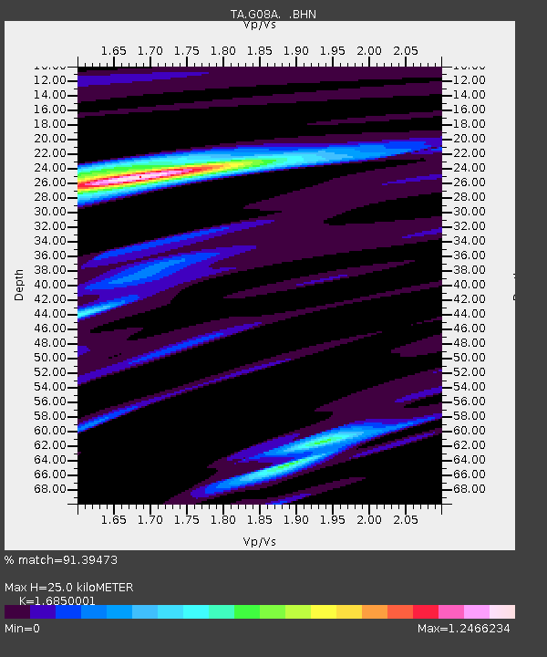
G08A Pilot Rock, OR, USA - Earthquake Result Viewer
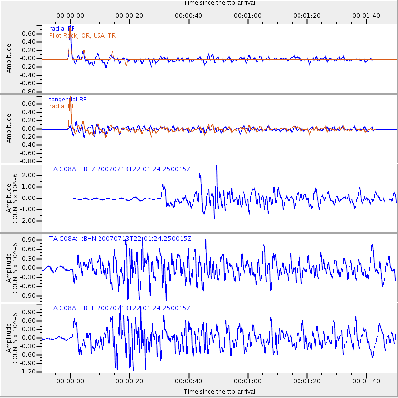
Earthquake location: Andreanof Islands, Aleutian Is.
Earthquake latitude/longitude: 51.8/-176.3
Earthquake time(UTC): 2007/07/13 (194) 21:54:43 GMT
Earthquake Depth: 35 km
Earthquake Magnitude: 5.7 MB, 5.6 MS, 6.0 MW, 5.9 MW
Earthquake Catalog/Contributor: WHDF/NEIC
Network: TA USArray Transportable Network (new EarthScope stations)
Station: G08A Pilot Rock, OR, USA
Lat/Lon: 45.29 N/118.96 W
Elevation: 1318 m
Distance: 37.6 deg
Az: 76.69 deg
Baz: 301.202 deg
Ray Param: 0.07595947
Estimated Moho Depth: 25.0 km
Estimated Crust Vp/Vs: 1.69
Assumed Crust Vp: 6.571 km/s
Estimated Crust Vs: 3.9 km/s
Estimated Crust Poisson's Ratio: 0.23
Radial Match: 91.39473 %
Radial Bump: 400
Transverse Match: 83.55871 %
Transverse Bump: 400
SOD ConfigId: 2564
Insert Time: 2010-03-07 01:41:15.213 +0000
GWidth: 2.5
Max Bumps: 400
Tol: 0.001

Signal To Noise

ChannelStoNSTALTA
TA:G08A: :BHN:20070713T22:01:24.250015Z5.14288852.0645923E-74.0144606E-8
TA:G08A: :BHE:20070713T22:01:24.250015Z10.2668293.437073E-73.347746E-8
TA:G08A: :BHZ:20070713T22:01:24.250015Z7.53855.7950547E-77.687278E-8
Arrivals
Ps2.8 SECOND
PpPs9.4 SECOND
PsPs/PpSs12 SECOND