You are here: Home > Network List > TA - USArray Transportable Network (new EarthScope stations) Stations List
> Station D28M Stokes Point, YT, CAN > Earthquake Result Viewer
D28M Stokes Point, YT, CAN - Earthquake Result Viewer
| Earthquake location: |
Northwest Of Ryukyu Islands |
| Earthquake latitude/longitude: |
29.4/128.2 |
| Earthquake time(UTC): |
2019/07/13 (194) 00:57:44 GMT |
| Earthquake Depth: |
251 km |
| Earthquake Magnitude: |
6.1 Mww |
| Earthquake Catalog/Contributor: |
NEIC PDE/us |
|
| Network: |
TA USArray Transportable Network (new EarthScope stations) |
| Station: |
D28M Stokes Point, YT, CAN |
| Lat/Lon: |
69.33 N/138.74 W |
| Elevation: |
32 m |
|
| Distance: |
64.0 deg |
| Az: |
23.244 deg |
| Baz: |
284.006 deg |
| Ray Param: |
0.058457814 |
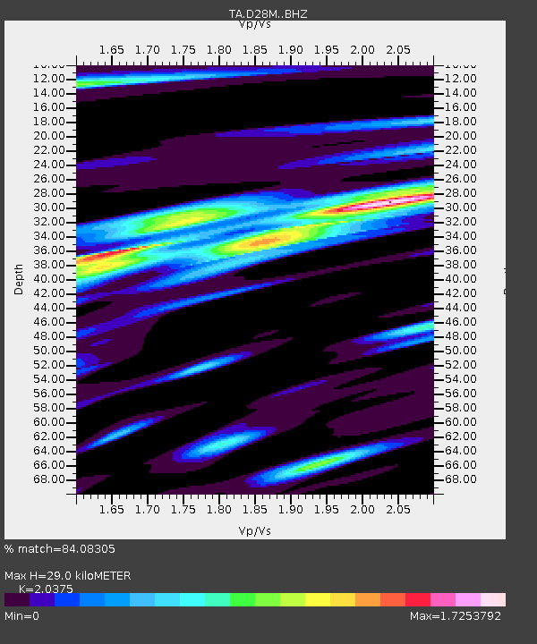
| Estimated Moho Depth: |
29.0 km |
| Estimated Crust Vp/Vs: |
2.04 |
| Assumed Crust Vp: |
6.316 km/s |
| Estimated Crust Vs: |
3.1 km/s |
| Estimated Crust Poisson's Ratio: |
0.34 |
|
| Radial Match: |
84.08305 % |
| Radial Bump: |
400 |
| Transverse Match: |
75.00306 % |
| Transverse Bump: |
400 |
| SOD ConfigId: |
19053131 |
| Insert Time: |
2019-07-27 01:06:14.671 +0000 |
| GWidth: |
2.5 |
| Max Bumps: |
400 |
| Tol: |
0.001 |
|

Signal To Noise
| Channel | StoN | STA | LTA |
| TA:D28M: :BHZ:20190713T01:07:19.974986Z | 12.090965 | 1.465436E-6 | 1.2120091E-7 |
| TA:D28M: :BHN:20190713T01:07:19.974986Z | 4.39009 | 3.6362513E-7 | 8.282863E-8 |
| TA:D28M: :BHE:20190713T01:07:19.974986Z | 5.657772 | 6.545863E-7 | 1.1569683E-7 |
| Arrivals |
| Ps | 4.9 SECOND |
| PpPs | 13 SECOND |
| PsPs/PpSs | 18 SECOND |


