You are here: Home > Network List > TA - USArray Transportable Network (new EarthScope stations) Stations List
> Station E20K Nigu River, AK, USA > Earthquake Result Viewer
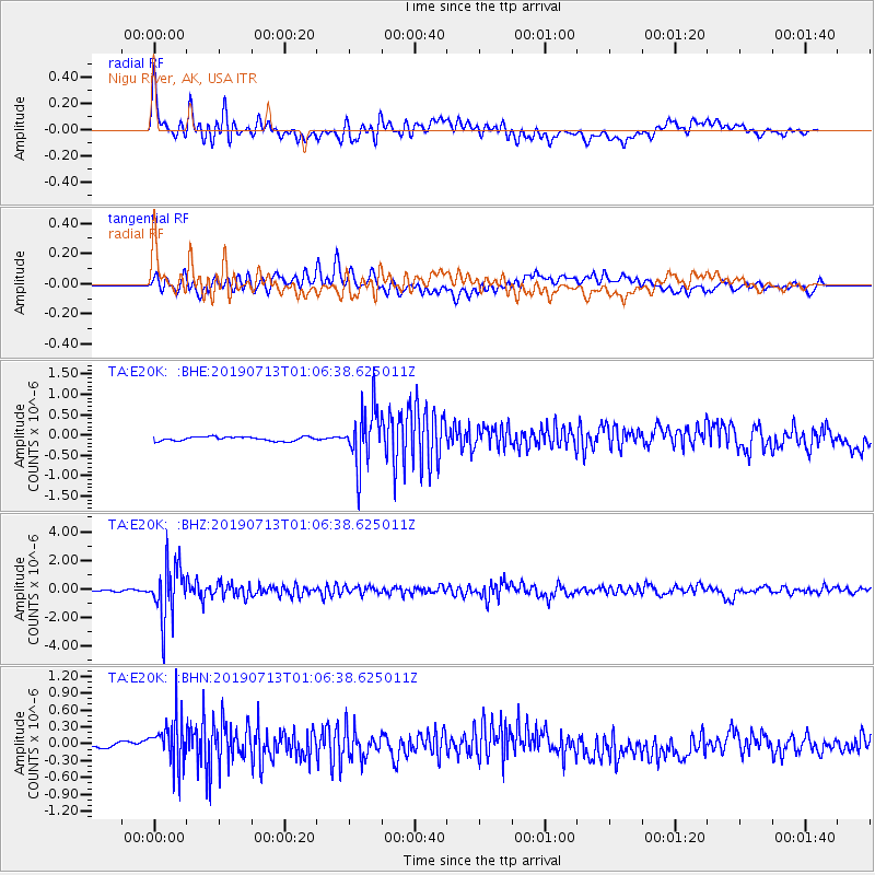
E20K Nigu River, AK, USA - Earthquake Result Viewer
*The percent match for this event was below the threshold and hence no stack was calculated.
| Earthquake location: |
Northwest Of Ryukyu Islands |
| Earthquake latitude/longitude: |
29.4/128.2 |
| Earthquake time(UTC): |
2019/07/13 (194) 00:57:44 GMT |
| Earthquake Depth: |
251 km |
| Earthquake Magnitude: |
6.1 Mww |
| Earthquake Catalog/Contributor: |
NEIC PDE/us |
|
| Network: |
TA USArray Transportable Network (new EarthScope stations) |
| Station: |
E20K Nigu River, AK, USA |
| Lat/Lon: |
68.26 N/156.19 W |
| Elevation: |
866 m |
|
| Distance: |
57.8 deg |
| Az: |
25.257 deg |
| Baz: |
268.715 deg |
| Ray Param: |
$rayparam |
*The percent match for this event was below the threshold and hence was not used in the summary stack. |
|
| Radial Match: |
77.63484 % |
| Radial Bump: |
400 |
| Transverse Match: |
60.53267 % |
| Transverse Bump: |
400 |
| SOD ConfigId: |
19053131 |
| Insert Time: |
2019-07-27 01:06:16.907 +0000 |
| GWidth: |
2.5 |
| Max Bumps: |
400 |
| Tol: |
0.001 |
|
Signal To Noise
| Channel | StoN | STA | LTA |
| TA:E20K: :BHZ:20190713T01:06:38.625011Z | 27.392036 | 1.900232E-6 | 6.9371694E-8 |
| TA:E20K: :BHN:20190713T01:06:38.625011Z | 8.029273 | 4.284671E-7 | 5.3363124E-8 |
| TA:E20K: :BHE:20190713T01:06:38.625011Z | 13.763826 | 6.942122E-7 | 5.0437443E-8 |
| Arrivals |
| Ps | |
| PpPs | |
| PsPs/PpSs | |


