You are here: Home > Network List > TA - USArray Transportable Network (new EarthScope stations) Stations List
> Station E24K Your Creek, AK, USA > Earthquake Result Viewer
E24K Your Creek, AK, USA - Earthquake Result Viewer
| Earthquake location: |
Northwest Of Ryukyu Islands |
| Earthquake latitude/longitude: |
29.4/128.2 |
| Earthquake time(UTC): |
2019/07/13 (194) 00:57:44 GMT |
| Earthquake Depth: |
251 km |
| Earthquake Magnitude: |
6.1 Mww |
| Earthquake Catalog/Contributor: |
NEIC PDE/us |
|
| Network: |
TA USArray Transportable Network (new EarthScope stations) |
| Station: |
E24K Your Creek, AK, USA |
| Lat/Lon: |
68.07 N/148.49 W |
| Elevation: |
847 m |
|
| Distance: |
60.7 deg |
| Az: |
25.335 deg |
| Baz: |
275.899 deg |
| Ray Param: |
0.060565256 |
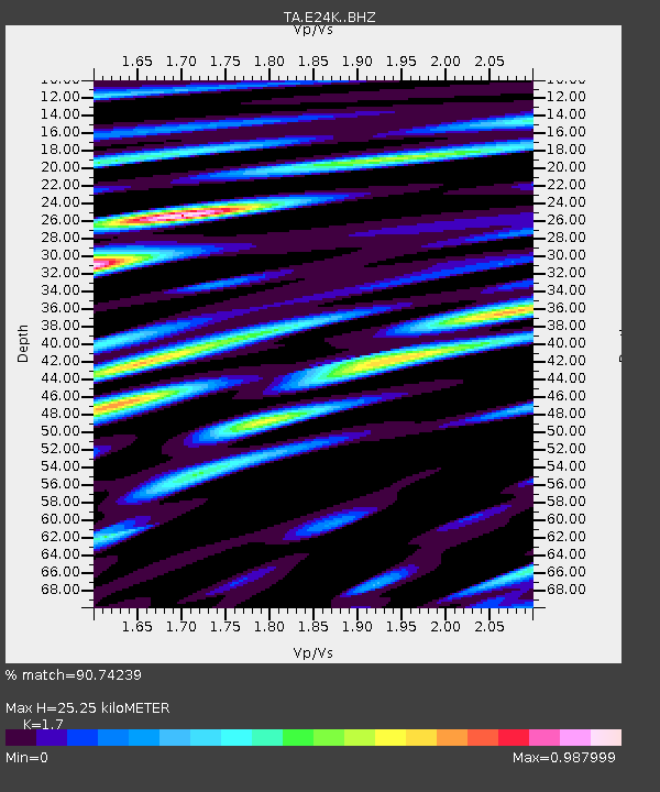
| Estimated Moho Depth: |
25.25 km |
| Estimated Crust Vp/Vs: |
1.70 |
| Assumed Crust Vp: |
6.316 km/s |
| Estimated Crust Vs: |
3.715 km/s |
| Estimated Crust Poisson's Ratio: |
0.24 |
|
| Radial Match: |
90.74239 % |
| Radial Bump: |
400 |
| Transverse Match: |
84.55757 % |
| Transverse Bump: |
400 |
| SOD ConfigId: |
19053131 |
| Insert Time: |
2019-07-27 01:06:18.528 +0000 |
| GWidth: |
2.5 |
| Max Bumps: |
400 |
| Tol: |
0.001 |
|

Signal To Noise
| Channel | StoN | STA | LTA |
| TA:E24K: :BHZ:20190713T01:06:58.274974Z | 41.585342 | 1.8400757E-6 | 4.4248182E-8 |
| TA:E24K: :BHN:20190713T01:06:58.274974Z | 9.982104 | 2.793634E-7 | 2.7986426E-8 |
| TA:E24K: :BHE:20190713T01:06:58.274974Z | 22.703743 | 5.6425677E-7 | 2.4853028E-8 |
| Arrivals |
| Ps | 2.9 SECOND |
| PpPs | 10 SECOND |
| PsPs/PpSs | 13 SECOND |


