You are here: Home > Network List > TA - USArray Transportable Network (new EarthScope stations) Stations List
> Station E27K Coleen River, AK, USA > Earthquake Result Viewer
E27K Coleen River, AK, USA - Earthquake Result Viewer
| Earthquake location: |
Northwest Of Ryukyu Islands |
| Earthquake latitude/longitude: |
29.4/128.2 |
| Earthquake time(UTC): |
2019/07/13 (194) 00:57:44 GMT |
| Earthquake Depth: |
251 km |
| Earthquake Magnitude: |
6.1 Mww |
| Earthquake Catalog/Contributor: |
NEIC PDE/us |
|
| Network: |
TA USArray Transportable Network (new EarthScope stations) |
| Station: |
E27K Coleen River, AK, USA |
| Lat/Lon: |
68.19 N/141.60 W |
| Elevation: |
654 m |
|
| Distance: |
63.2 deg |
| Az: |
24.755 deg |
| Baz: |
282.017 deg |
| Ray Param: |
0.058939017 |
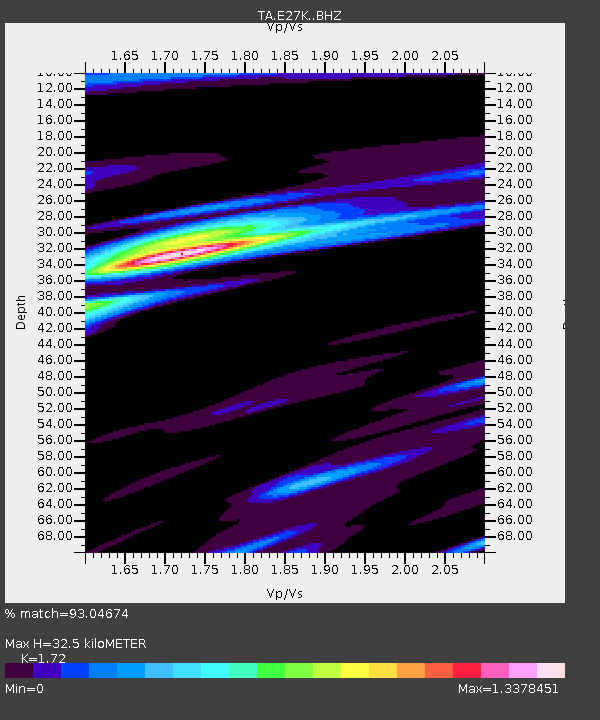
| Estimated Moho Depth: |
32.5 km |
| Estimated Crust Vp/Vs: |
1.72 |
| Assumed Crust Vp: |
6.522 km/s |
| Estimated Crust Vs: |
3.792 km/s |
| Estimated Crust Poisson's Ratio: |
0.24 |
|
| Radial Match: |
93.04674 % |
| Radial Bump: |
400 |
| Transverse Match: |
74.69172 % |
| Transverse Bump: |
400 |
| SOD ConfigId: |
19053131 |
| Insert Time: |
2019-07-27 01:06:20.115 +0000 |
| GWidth: |
2.5 |
| Max Bumps: |
400 |
| Tol: |
0.001 |
|

Signal To Noise
| Channel | StoN | STA | LTA |
| TA:E27K: :BHZ:20190713T01:07:15.049999Z | 46.10546 | 1.5138818E-6 | 3.2835192E-8 |
| TA:E27K: :BHN:20190713T01:07:15.049999Z | 7.9183254 | 2.659393E-7 | 3.3585298E-8 |
| TA:E27K: :BHE:20190713T01:07:15.049999Z | 19.994612 | 6.227708E-7 | 3.114693E-8 |
| Arrivals |
| Ps | 3.8 SECOND |
| PpPs | 13 SECOND |
| PsPs/PpSs | 17 SECOND |


