You are here: Home > Network List > TA - USArray Transportable Network (new EarthScope stations) Stations List
> Station G08A Pilot Rock, OR, USA > Earthquake Result Viewer
G08A Pilot Rock, OR, USA - Earthquake Result Viewer
| Earthquake location: |
Kamchatka Peninsula, Russia |
| Earthquake latitude/longitude: |
52.1/157.3 |
| Earthquake time(UTC): |
2007/05/30 (150) 20:22:12 GMT |
| Earthquake Depth: |
116 km |
| Earthquake Magnitude: |
6.4 MB, 6.4 MW, 6.4 MW |
| Earthquake Catalog/Contributor: |
WHDF/NEIC |
|
| Network: |
TA USArray Transportable Network (new EarthScope stations) |
| Station: |
G08A Pilot Rock, OR, USA |
| Lat/Lon: |
45.29 N/118.96 W |
| Elevation: |
1318 m |
|
| Distance: |
52.8 deg |
| Az: |
61.814 deg |
| Baz: |
309.682 deg |
| Ray Param: |
0.06617035 |
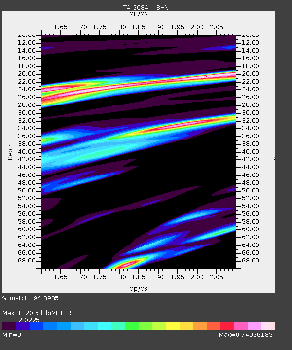
| Estimated Moho Depth: |
20.5 km |
| Estimated Crust Vp/Vs: |
2.02 |
| Assumed Crust Vp: |
6.571 km/s |
| Estimated Crust Vs: |
3.249 km/s |
| Estimated Crust Poisson's Ratio: |
0.34 |
|
| Radial Match: |
94.3985 % |
| Radial Bump: |
400 |
| Transverse Match: |
83.21087 % |
| Transverse Bump: |
400 |
| SOD ConfigId: |
2564 |
| Insert Time: |
2010-03-07 01:41:27.926 +0000 |
| GWidth: |
2.5 |
| Max Bumps: |
400 |
| Tol: |
0.001 |
|

Signal To Noise
| Channel | StoN | STA | LTA |
| TA:G08A: :BHN:20070530T20:30:45.125027Z | 20.721613 | 1.1352099E-6 | 5.478386E-8 |
| TA:G08A: :BHE:20070530T20:30:45.125027Z | 24.392538 | 1.3503852E-6 | 5.5360587E-8 |
| TA:G08A: :BHZ:20070530T20:30:45.125027Z | 42.96157 | 3.0080837E-6 | 7.001801E-8 |
| Arrivals |
| Ps | 3.4 SECOND |
| PpPs | 9.0 SECOND |
| PsPs/PpSs | 12 SECOND |


