You are here: Home > Network List > TA - USArray Transportable Network (new EarthScope stations) Stations List
> Station G18K Tagagawik, AK, USA > Earthquake Result Viewer
G18K Tagagawik, AK, USA - Earthquake Result Viewer
| Earthquake location: |
Northwest Of Ryukyu Islands |
| Earthquake latitude/longitude: |
29.4/128.2 |
| Earthquake time(UTC): |
2019/07/13 (194) 00:57:44 GMT |
| Earthquake Depth: |
251 km |
| Earthquake Magnitude: |
6.1 Mww |
| Earthquake Catalog/Contributor: |
NEIC PDE/us |
|
| Network: |
TA USArray Transportable Network (new EarthScope stations) |
| Station: |
G18K Tagagawik, AK, USA |
| Lat/Lon: |
65.89 N/158.65 W |
| Elevation: |
484 m |
|
| Distance: |
56.7 deg |
| Az: |
28.043 deg |
| Baz: |
267.953 deg |
| Ray Param: |
0.063080266 |
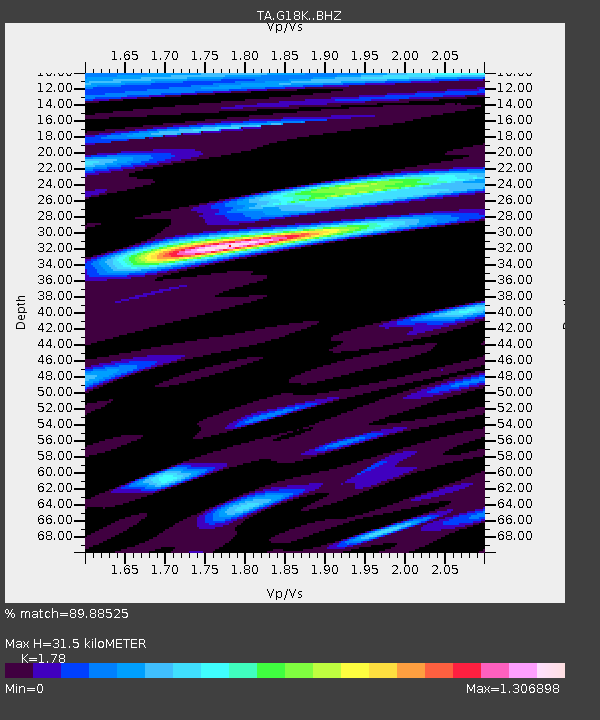
| Estimated Moho Depth: |
31.5 km |
| Estimated Crust Vp/Vs: |
1.78 |
| Assumed Crust Vp: |
6.1 km/s |
| Estimated Crust Vs: |
3.427 km/s |
| Estimated Crust Poisson's Ratio: |
0.27 |
|
| Radial Match: |
89.88525 % |
| Radial Bump: |
400 |
| Transverse Match: |
83.56734 % |
| Transverse Bump: |
400 |
| SOD ConfigId: |
19053131 |
| Insert Time: |
2019-07-27 01:06:32.184 +0000 |
| GWidth: |
2.5 |
| Max Bumps: |
400 |
| Tol: |
0.001 |
|

Signal To Noise
| Channel | StoN | STA | LTA |
| TA:G18K: :BHZ:20190713T01:06:31.424999Z | 33.080925 | 1.9514052E-6 | 5.898883E-8 |
| TA:G18K: :BHN:20190713T01:06:31.424999Z | 6.9340825 | 2.7212738E-7 | 3.9244902E-8 |
| TA:G18K: :BHE:20190713T01:06:31.424999Z | 23.918013 | 7.319521E-7 | 3.0602546E-8 |
| Arrivals |
| Ps | 4.2 SECOND |
| PpPs | 14 SECOND |
| PsPs/PpSs | 18 SECOND |


