You are here: Home > Network List > TA - USArray Transportable Network (new EarthScope stations) Stations List
> Station H27K Steamboat Mountain, AK, USA > Earthquake Result Viewer
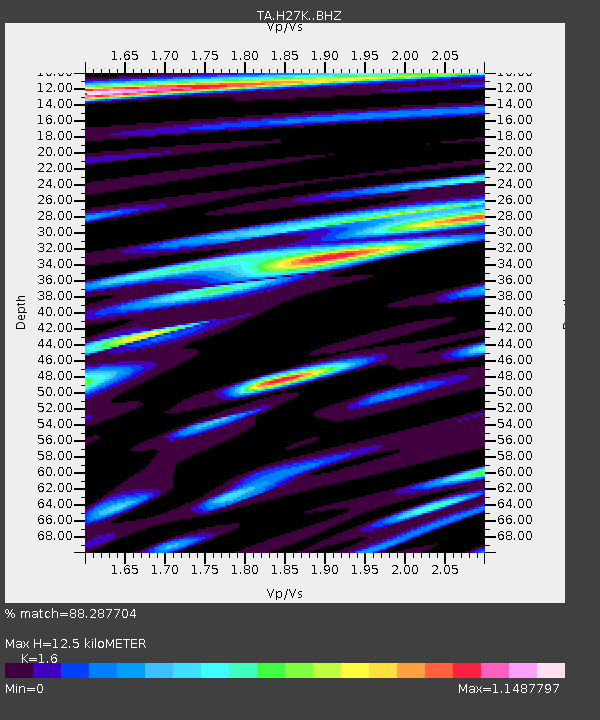
H27K Steamboat Mountain, AK, USA - Earthquake Result Viewer
| Earthquake location: |
Northwest Of Ryukyu Islands |
| Earthquake latitude/longitude: |
29.4/128.2 |
| Earthquake time(UTC): |
2019/07/13 (194) 00:57:44 GMT |
| Earthquake Depth: |
251 km |
| Earthquake Magnitude: |
6.1 Mww |
| Earthquake Catalog/Contributor: |
NEIC PDE/us |
|
| Network: |
TA USArray Transportable Network (new EarthScope stations) |
| Station: |
H27K Steamboat Mountain, AK, USA |
| Lat/Lon: |
66.23 N/141.53 W |
| Elevation: |
786 m |
|
| Distance: |
63.6 deg |
| Az: |
26.893 deg |
| Baz: |
283.037 deg |
| Ray Param: |
0.058654163 |
| Estimated Moho Depth: |
12.5 km |
| Estimated Crust Vp/Vs: |
1.60 |
| Assumed Crust Vp: |
6.577 km/s |
| Estimated Crust Vs: |
4.11 km/s |
| Estimated Crust Poisson's Ratio: |
0.18 |
|
| Radial Match: |
88.287704 % |
| Radial Bump: |
400 |
| Transverse Match: |
86.29863 % |
| Transverse Bump: |
400 |
| SOD ConfigId: |
19053131 |
| Insert Time: |
2019-07-27 01:06:43.523 +0000 |
| GWidth: |
2.5 |
| Max Bumps: |
400 |
| Tol: |
0.001 |
|

Signal To Noise
| Channel | StoN | STA | LTA |
| TA:H27K: :BHZ:20190713T01:07:18.000011Z | 29.170334 | 1.3543588E-6 | 4.642932E-8 |
| TA:H27K: :BHN:20190713T01:07:18.000011Z | 3.9591534 | 1.9279878E-7 | 4.8696972E-8 |
| TA:H27K: :BHE:20190713T01:07:18.000011Z | 20.622574 | 6.3846846E-7 | 3.095969E-8 |
| Arrivals |
| Ps | 1.2 SECOND |
| PpPs | 4.7 SECOND |
| PsPs/PpSs | 5.9 SECOND |


