You are here: Home > Network List > TA - USArray Transportable Network (new EarthScope stations) Stations List
> Station H31M Peel River, Yukon, CAN > Earthquake Result Viewer
H31M Peel River, Yukon, CAN - Earthquake Result Viewer
| Earthquake location: |
Northwest Of Ryukyu Islands |
| Earthquake latitude/longitude: |
29.4/128.2 |
| Earthquake time(UTC): |
2019/07/13 (194) 00:57:44 GMT |
| Earthquake Depth: |
251 km |
| Earthquake Magnitude: |
6.1 Mww |
| Earthquake Catalog/Contributor: |
NEIC PDE/us |
|
| Network: |
TA USArray Transportable Network (new EarthScope stations) |
| Station: |
H31M Peel River, Yukon, CAN |
| Lat/Lon: |
65.81 N/134.34 W |
| Elevation: |
642 m |
|
| Distance: |
66.6 deg |
| Az: |
26.44 deg |
| Baz: |
289.404 deg |
| Ray Param: |
0.056757756 |
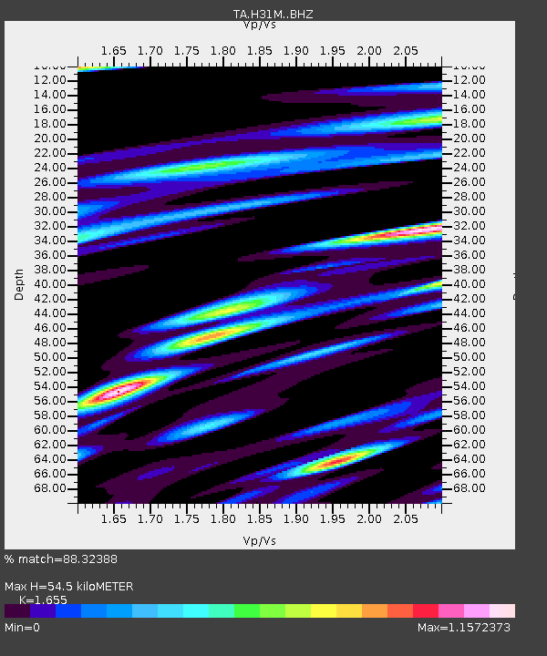
| Estimated Moho Depth: |
54.5 km |
| Estimated Crust Vp/Vs: |
1.65 |
| Assumed Crust Vp: |
6.419 km/s |
| Estimated Crust Vs: |
3.879 km/s |
| Estimated Crust Poisson's Ratio: |
0.21 |
|
| Radial Match: |
88.32388 % |
| Radial Bump: |
400 |
| Transverse Match: |
70.540115 % |
| Transverse Bump: |
400 |
| SOD ConfigId: |
19053131 |
| Insert Time: |
2019-07-27 01:06:43.831 +0000 |
| GWidth: |
2.5 |
| Max Bumps: |
400 |
| Tol: |
0.001 |
|
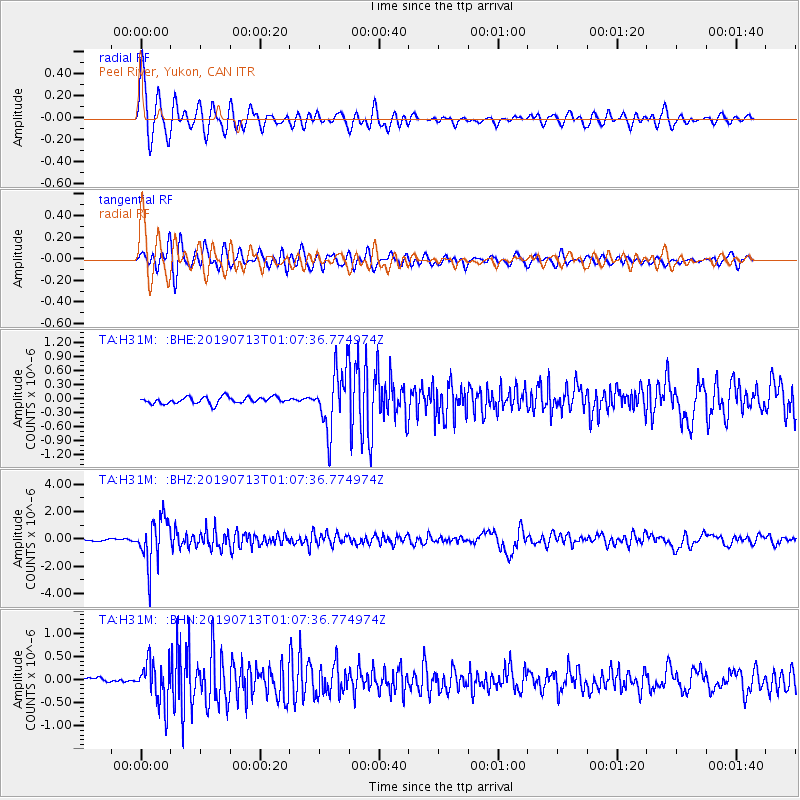
Signal To Noise
| Channel | StoN | STA | LTA |
| TA:H31M: :BHZ:20190713T01:07:36.774974Z | 30.842428 | 1.6671099E-6 | 5.4052485E-8 |
| TA:H31M: :BHN:20190713T01:07:36.774974Z | 5.2297015 | 4.500835E-7 | 8.606294E-8 |
| TA:H31M: :BHE:20190713T01:07:36.774974Z | 9.090333 | 6.281072E-7 | 6.909617E-8 |
| Arrivals |
| Ps | 5.8 SECOND |
| PpPs | 22 SECOND |
| PsPs/PpSs | 27 SECOND |


