You are here: Home > Network List > TA - USArray Transportable Network (new EarthScope stations) Stations List
> Station G08A Pilot Rock, OR, USA > Earthquake Result Viewer
G08A Pilot Rock, OR, USA - Earthquake Result Viewer

| Earthquake location: |
Tonga Islands |
| Earthquake latitude/longitude: |
-21.3/-174.7 |
| Earthquake time(UTC): |
2006/11/30 (334) 11:33:17 GMT |
| Earthquake Depth: |
14 km |
| Earthquake Magnitude: |
5.7 MB, 6.1 MS, 6.0 MW, 6.0 MW |
| Earthquake Catalog/Contributor: |
WHDF/NEIC |
|
| Network: |
TA USArray Transportable Network (new EarthScope stations) |
| Station: |
G08A Pilot Rock, OR, USA |
| Lat/Lon: |
45.29 N/118.96 W |
| Elevation: |
1318 m |
|
| Distance: |
83.4 deg |
| Az: |
35.956 deg |
| Baz: |
230.866 deg |
| Ray Param: |
0.0462127 |
| Estimated Moho Depth: |
51.25 km |
| Estimated Crust Vp/Vs: |
2.10 |
| Assumed Crust Vp: |
6.571 km/s |
| Estimated Crust Vs: |
3.133 km/s |
| Estimated Crust Poisson's Ratio: |
0.35 |
|
| Radial Match: |
80.670235 % |
| Radial Bump: |
400 |
| Transverse Match: |
64.242455 % |
| Transverse Bump: |
379 |
| SOD ConfigId: |
2564 |
| Insert Time: |
2010-03-07 01:41:43.162 +0000 |
| GWidth: |
2.5 |
| Max Bumps: |
400 |
| Tol: |
0.001 |
|
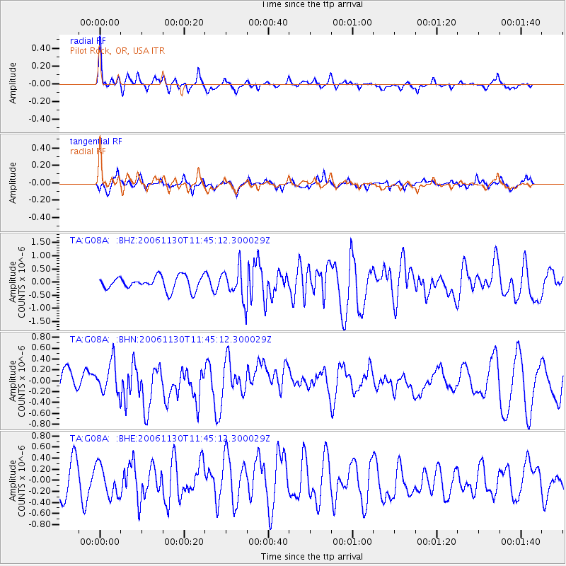
Signal To Noise
| Channel | StoN | STA | LTA |
| TA:G08A: :BHN:20061130T11:45:12.300029Z | 2.0337083 | 2.9432843E-7 | 1.4472499E-7 |
| TA:G08A: :BHE:20061130T11:45:12.300029Z | 0.96207225 | 2.7796563E-7 | 2.8892384E-7 |
| TA:G08A: :BHZ:20061130T11:45:12.300029Z | 2.3932133 | 6.197837E-7 | 2.5897555E-7 |
| Arrivals |
| Ps | 8.8 SECOND |
| PpPs | 24 SECOND |
| PsPs/PpSs | 32 SECOND |


