You are here: Home > Network List > TA - USArray Transportable Network (new EarthScope stations) Stations List
> Station L15K Ungalak Mountain, AK, USA > Earthquake Result Viewer
L15K Ungalak Mountain, AK, USA - Earthquake Result Viewer
| Earthquake location: |
Northwest Of Ryukyu Islands |
| Earthquake latitude/longitude: |
29.4/128.2 |
| Earthquake time(UTC): |
2019/07/13 (194) 00:57:44 GMT |
| Earthquake Depth: |
251 km |
| Earthquake Magnitude: |
6.1 Mww |
| Earthquake Catalog/Contributor: |
NEIC PDE/us |
|
| Network: |
TA USArray Transportable Network (new EarthScope stations) |
| Station: |
L15K Ungalak Mountain, AK, USA |
| Lat/Lon: |
61.68 N/161.49 W |
| Elevation: |
219 m |
|
| Distance: |
55.3 deg |
| Az: |
33.094 deg |
| Baz: |
268.235 deg |
| Ray Param: |
0.06396876 |
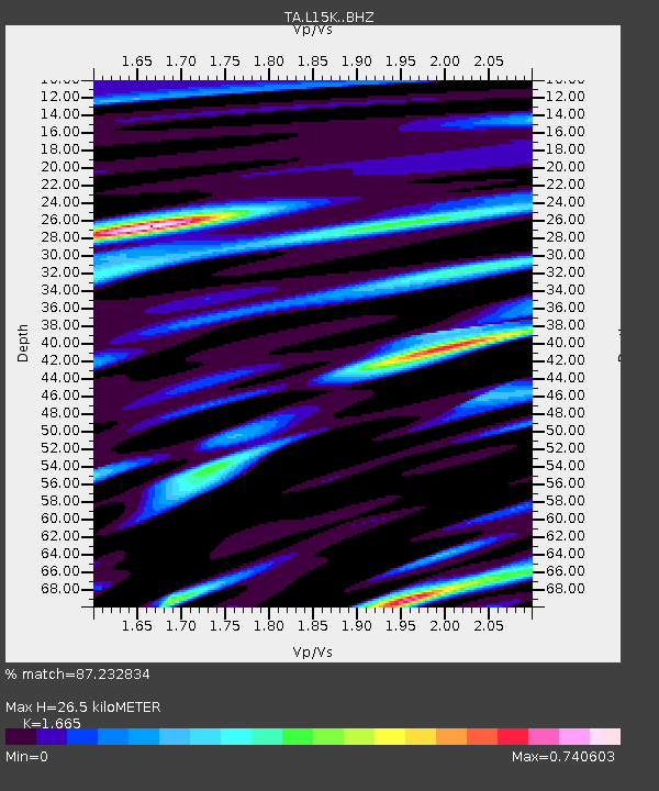
| Estimated Moho Depth: |
26.5 km |
| Estimated Crust Vp/Vs: |
1.66 |
| Assumed Crust Vp: |
6.182 km/s |
| Estimated Crust Vs: |
3.713 km/s |
| Estimated Crust Poisson's Ratio: |
0.22 |
|
| Radial Match: |
87.232834 % |
| Radial Bump: |
400 |
| Transverse Match: |
61.00671 % |
| Transverse Bump: |
400 |
| SOD ConfigId: |
19053131 |
| Insert Time: |
2019-07-27 01:07:00.917 +0000 |
| GWidth: |
2.5 |
| Max Bumps: |
400 |
| Tol: |
0.001 |
|
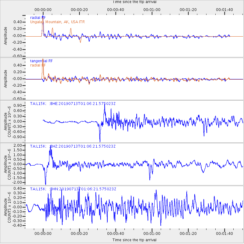
Signal To Noise
| Channel | StoN | STA | LTA |
| TA:L15K: :BHZ:20190713T01:06:21.575023Z | 15.149168 | 9.728559E-7 | 6.421844E-8 |
| TA:L15K: :BHN:20190713T01:06:21.575023Z | 2.7695608 | 1.4256976E-7 | 5.147739E-8 |
| TA:L15K: :BHE:20190713T01:06:21.575023Z | 10.537911 | 4.1505254E-7 | 3.9386602E-8 |
| Arrivals |
| Ps | 3.0 SECOND |
| PpPs | 11 SECOND |
| PsPs/PpSs | 14 SECOND |


