You are here: Home > Network List > TA - USArray Transportable Network (new EarthScope stations) Stations List
> Station M16K Timber Creek, AK, USA > Earthquake Result Viewer
M16K Timber Creek, AK, USA - Earthquake Result Viewer

| Earthquake location: |
Northwest Of Ryukyu Islands |
| Earthquake latitude/longitude: |
29.4/128.2 |
| Earthquake time(UTC): |
2019/07/13 (194) 00:57:44 GMT |
| Earthquake Depth: |
251 km |
| Earthquake Magnitude: |
6.1 Mww |
| Earthquake Catalog/Contributor: |
NEIC PDE/us |
|
| Network: |
TA USArray Transportable Network (new EarthScope stations) |
| Station: |
M16K Timber Creek, AK, USA |
| Lat/Lon: |
61.02 N/158.96 W |
| Elevation: |
394 m |
|
| Distance: |
56.6 deg |
| Az: |
33.898 deg |
| Baz: |
270.901 deg |
| Ray Param: |
0.06319948 |
| Estimated Moho Depth: |
31.5 km |
| Estimated Crust Vp/Vs: |
1.85 |
| Assumed Crust Vp: |
6.276 km/s |
| Estimated Crust Vs: |
3.388 km/s |
| Estimated Crust Poisson's Ratio: |
0.29 |
|
| Radial Match: |
83.40902 % |
| Radial Bump: |
400 |
| Transverse Match: |
67.521545 % |
| Transverse Bump: |
400 |
| SOD ConfigId: |
19053131 |
| Insert Time: |
2019-07-27 01:07:07.523 +0000 |
| GWidth: |
2.5 |
| Max Bumps: |
400 |
| Tol: |
0.001 |
|
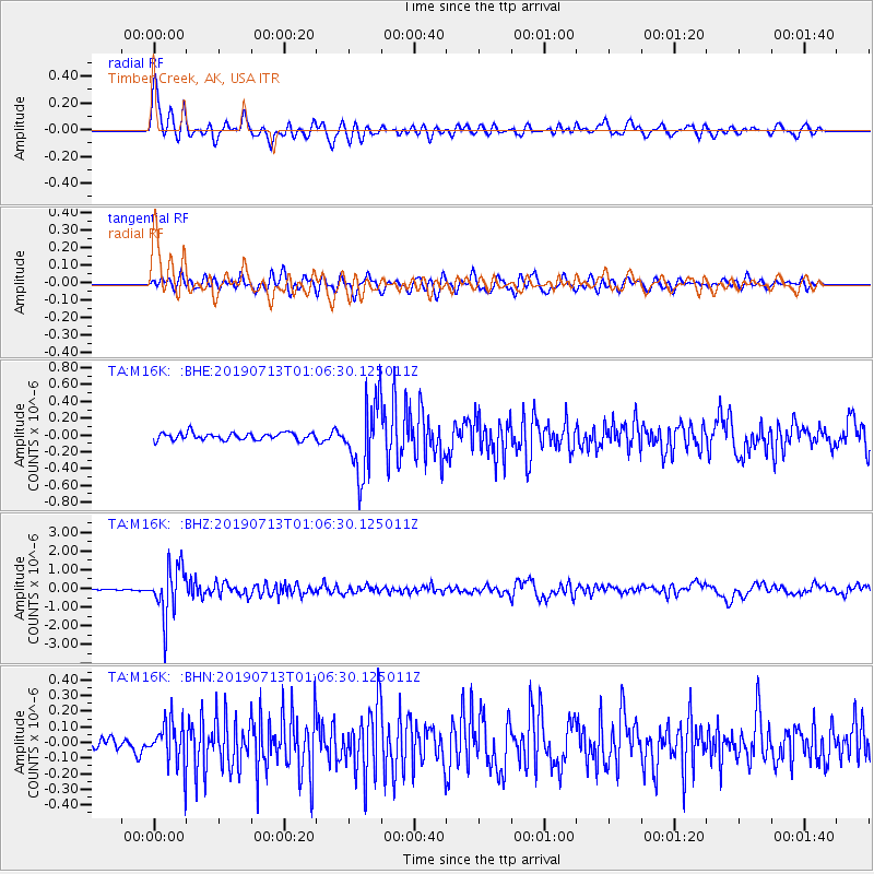
Signal To Noise
| Channel | StoN | STA | LTA |
| TA:M16K: :BHZ:20190713T01:06:30.125011Z | 29.405659 | 1.3242923E-6 | 4.503529E-8 |
| TA:M16K: :BHN:20190713T01:06:30.125011Z | 3.0754502 | 1.4117462E-7 | 4.5903725E-8 |
| TA:M16K: :BHE:20190713T01:06:30.125011Z | 9.903273 | 4.2422442E-7 | 4.2836792E-8 |
| Arrivals |
| Ps | 4.5 SECOND |
| PpPs | 14 SECOND |
| PsPs/PpSs | 18 SECOND |


