You are here: Home > Network List > TA - USArray Transportable Network (new EarthScope stations) Stations List
> Station G08A Pilot Rock, OR, USA > Earthquake Result Viewer
G08A Pilot Rock, OR, USA - Earthquake Result Viewer
| Earthquake location: |
Near East Coast Of Kamchatka |
| Earthquake latitude/longitude: |
51.1/157.5 |
| Earthquake time(UTC): |
2006/08/24 (236) 21:50:36 GMT |
| Earthquake Depth: |
43 km |
| Earthquake Magnitude: |
5.9 MB, 6.2 MS, 6.5 MW, 6.5 MW |
| Earthquake Catalog/Contributor: |
WHDF/NEIC |
|
| Network: |
TA USArray Transportable Network (new EarthScope stations) |
| Station: |
G08A Pilot Rock, OR, USA |
| Lat/Lon: |
45.29 N/118.96 W |
| Elevation: |
1318 m |
|
| Distance: |
53.1 deg |
| Az: |
61.284 deg |
| Baz: |
308.505 deg |
| Ray Param: |
0.0662233 |
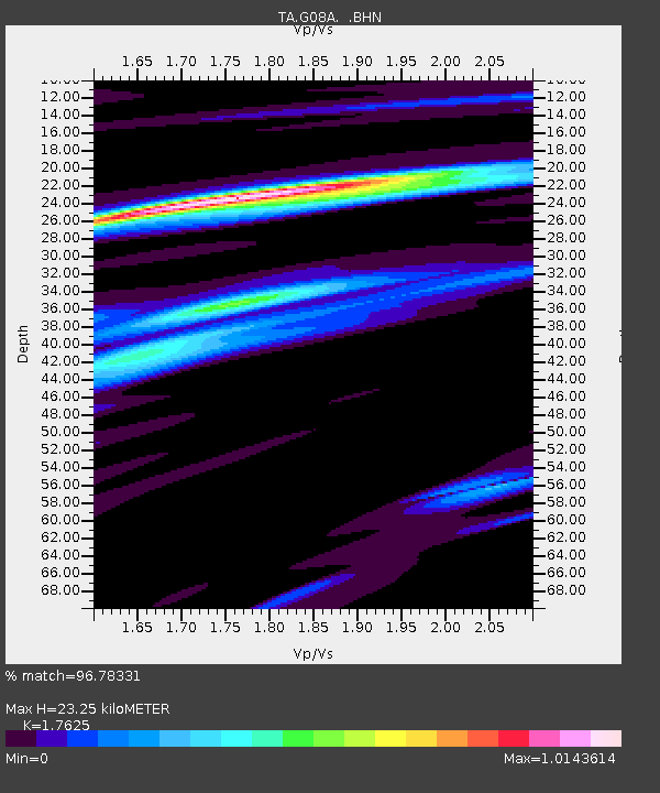
| Estimated Moho Depth: |
23.25 km |
| Estimated Crust Vp/Vs: |
1.76 |
| Assumed Crust Vp: |
6.571 km/s |
| Estimated Crust Vs: |
3.728 km/s |
| Estimated Crust Poisson's Ratio: |
0.26 |
|
| Radial Match: |
96.78331 % |
| Radial Bump: |
308 |
| Transverse Match: |
78.650696 % |
| Transverse Bump: |
400 |
| SOD ConfigId: |
2564 |
| Insert Time: |
2010-03-07 01:41:49.178 +0000 |
| GWidth: |
2.5 |
| Max Bumps: |
400 |
| Tol: |
0.001 |
|
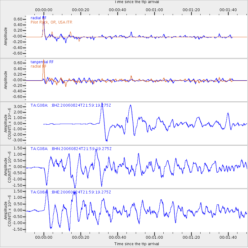
Signal To Noise
| Channel | StoN | STA | LTA |
| TA:G08A: :BHN:20060824T21:59:19.275Z | 15.517854 | 6.8148995E-7 | 4.391651E-8 |
| TA:G08A: :BHE:20060824T21:59:19.275Z | 17.956495 | 9.433082E-7 | 5.2532975E-8 |
| TA:G08A: :BHZ:20060824T21:59:19.275Z | 50.835197 | 2.1268568E-6 | 4.183827E-8 |
| Arrivals |
| Ps | 2.9 SECOND |
| PpPs | 9.2 SECOND |
| PsPs/PpSs | 12 SECOND |


