You are here: Home > Network List > TA - USArray Transportable Network (new EarthScope stations) Stations List
> Station O17K Koliganek, Bristol Bay, AK, USA > Earthquake Result Viewer
O17K Koliganek, Bristol Bay, AK, USA - Earthquake Result Viewer
| Earthquake location: |
Northwest Of Ryukyu Islands |
| Earthquake latitude/longitude: |
29.4/128.2 |
| Earthquake time(UTC): |
2019/07/13 (194) 00:57:44 GMT |
| Earthquake Depth: |
251 km |
| Earthquake Magnitude: |
6.1 Mww |
| Earthquake Catalog/Contributor: |
NEIC PDE/us |
|
| Network: |
TA USArray Transportable Network (new EarthScope stations) |
| Station: |
O17K Koliganek, Bristol Bay, AK, USA |
| Lat/Lon: |
59.77 N/157.09 W |
| Elevation: |
156 m |
|
| Distance: |
57.5 deg |
| Az: |
35.35 deg |
| Baz: |
273.309 deg |
| Ray Param: |
0.062577985 |
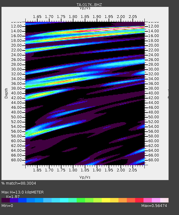
| Estimated Moho Depth: |
13.0 km |
| Estimated Crust Vp/Vs: |
1.97 |
| Assumed Crust Vp: |
6.276 km/s |
| Estimated Crust Vs: |
3.186 km/s |
| Estimated Crust Poisson's Ratio: |
0.33 |
|
| Radial Match: |
88.3004 % |
| Radial Bump: |
400 |
| Transverse Match: |
71.176994 % |
| Transverse Bump: |
400 |
| SOD ConfigId: |
19053131 |
| Insert Time: |
2019-07-27 01:07:22.465 +0000 |
| GWidth: |
2.5 |
| Max Bumps: |
400 |
| Tol: |
0.001 |
|
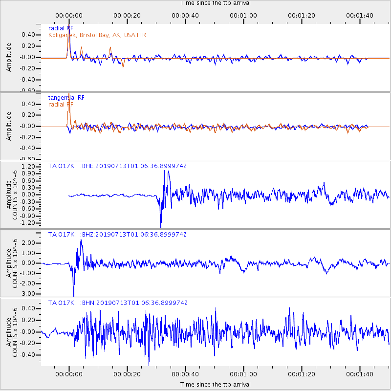
Signal To Noise
| Channel | StoN | STA | LTA |
| TA:O17K: :BHZ:20190713T01:06:36.899974Z | 19.666254 | 1.2018054E-6 | 6.1110036E-8 |
| TA:O17K: :BHN:20190713T01:06:36.899974Z | 1.7943355 | 9.487139E-8 | 5.2872714E-8 |
| TA:O17K: :BHE:20190713T01:06:36.899974Z | 17.676998 | 5.487489E-7 | 3.1043108E-8 |
| Arrivals |
| Ps | 2.1 SECOND |
| PpPs | 5.9 SECOND |
| PsPs/PpSs | 8.0 SECOND |


