You are here: Home > Network List > TA - USArray Transportable Network (new EarthScope stations) Stations List
> Station O29M Mount Kennedy, YT, CAN > Earthquake Result Viewer
O29M Mount Kennedy, YT, CAN - Earthquake Result Viewer

| Earthquake location: |
Northwest Of Ryukyu Islands |
| Earthquake latitude/longitude: |
29.4/128.2 |
| Earthquake time(UTC): |
2019/07/13 (194) 00:57:44 GMT |
| Earthquake Depth: |
251 km |
| Earthquake Magnitude: |
6.1 Mww |
| Earthquake Catalog/Contributor: |
NEIC PDE/us |
|
| Network: |
TA USArray Transportable Network (new EarthScope stations) |
| Station: |
O29M Mount Kennedy, YT, CAN |
| Lat/Lon: |
60.30 N/138.58 W |
| Elevation: |
1423 m |
|
| Distance: |
66.5 deg |
| Az: |
32.815 deg |
| Baz: |
288.169 deg |
| Ray Param: |
0.056788556 |
| Estimated Moho Depth: |
49.5 km |
| Estimated Crust Vp/Vs: |
1.66 |
| Assumed Crust Vp: |
6.566 km/s |
| Estimated Crust Vs: |
3.956 km/s |
| Estimated Crust Poisson's Ratio: |
0.22 |
|
| Radial Match: |
84.37672 % |
| Radial Bump: |
400 |
| Transverse Match: |
86.246124 % |
| Transverse Bump: |
400 |
| SOD ConfigId: |
19053131 |
| Insert Time: |
2019-07-27 01:07:25.845 +0000 |
| GWidth: |
2.5 |
| Max Bumps: |
400 |
| Tol: |
0.001 |
|
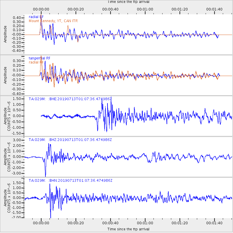
Signal To Noise
| Channel | StoN | STA | LTA |
| TA:O29M: :BHZ:20190713T01:07:36.474986Z | 19.203518 | 1.156321E-6 | 6.021402E-8 |
| TA:O29M: :BHN:20190713T01:07:36.474986Z | 3.4907935 | 2.2042774E-7 | 6.314546E-8 |
| TA:O29M: :BHE:20190713T01:07:36.474986Z | 5.214587 | 3.884816E-7 | 7.449901E-8 |
| Arrivals |
| Ps | 5.2 SECOND |
| PpPs | 19 SECOND |
| PsPs/PpSs | 24 SECOND |


