You are here: Home > Network List > G - GEOSCOPE Stations List
> Station AIS New Amsterdam, Indian Ocean > Earthquake Result Viewer
AIS New Amsterdam, Indian Ocean - Earthquake Result Viewer

| Earthquake location: |
New Ireland Region, P.N.G. |
| Earthquake latitude/longitude: |
-4.4/153.5 |
| Earthquake time(UTC): |
2016/12/17 (352) 11:22:39 GMT |
| Earthquake Depth: |
83 km |
| Earthquake Magnitude: |
5.6 mb |
| Earthquake Catalog/Contributor: |
NEIC PDE/us |
|
| Network: |
G GEOSCOPE |
| Station: |
AIS New Amsterdam, Indian Ocean |
| Lat/Lon: |
37.80 S/77.57 E |
| Elevation: |
35 m |
|
| Distance: |
76.2 deg |
| Az: |
232.31 deg |
| Baz: |
84.873 deg |
| Ray Param: |
0.050956443 |
| Estimated Moho Depth: |
35.5 km |
| Estimated Crust Vp/Vs: |
1.79 |
| Assumed Crust Vp: |
4.802 km/s |
| Estimated Crust Vs: |
2.679 km/s |
| Estimated Crust Poisson's Ratio: |
0.27 |
|
| Radial Match: |
92.953 % |
| Radial Bump: |
400 |
| Transverse Match: |
55.31113 % |
| Transverse Bump: |
400 |
| SOD ConfigId: |
1894071 |
| Insert Time: |
2016-12-31 11:23:25.994 +0000 |
| GWidth: |
2.5 |
| Max Bumps: |
400 |
| Tol: |
0.001 |
|
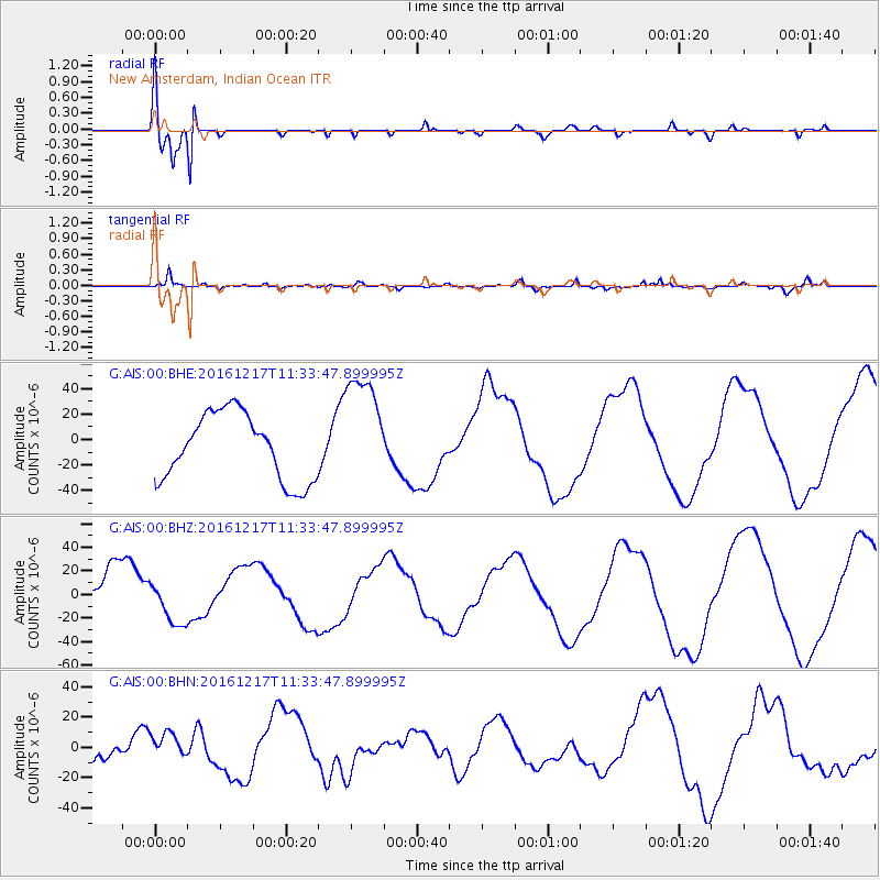
Signal To Noise
| Channel | StoN | STA | LTA |
| G:AIS:00:BHZ:20161217T11:33:47.899995Z | 0.76044935 | 1.9411704E-5 | 2.5526622E-5 |
| G:AIS:00:BHN:20161217T11:33:47.899995Z | 0.6018364 | 8.928495E-6 | 1.4835418E-5 |
| G:AIS:00:BHE:20161217T11:33:47.899995Z | 1.7454153 | 4.562675E-5 | 2.6140913E-5 |
| Arrivals |
| Ps | 6.0 SECOND |
| PpPs | 20 SECOND |
| PsPs/PpSs | 26 SECOND |


