You are here: Home > Network List > G - GEOSCOPE Stations List
> Station CRZF Port Alfred, Crozet, South Indian Ocean > Earthquake Result Viewer
CRZF Port Alfred, Crozet, South Indian Ocean - Earthquake Result Viewer
| Earthquake location: |
New Ireland Region, P.N.G. |
| Earthquake latitude/longitude: |
-4.4/153.5 |
| Earthquake time(UTC): |
2016/12/17 (352) 11:22:39 GMT |
| Earthquake Depth: |
83 km |
| Earthquake Magnitude: |
5.6 mb |
| Earthquake Catalog/Contributor: |
NEIC PDE/us |
|
| Network: |
G GEOSCOPE |
| Station: |
CRZF Port Alfred, Crozet, South Indian Ocean |
| Lat/Lon: |
46.43 S/51.86 E |
| Elevation: |
140 m |
|
| Distance: |
94.8 deg |
| Az: |
222.825 deg |
| Baz: |
101.508 deg |
| Ray Param: |
0.040885728 |
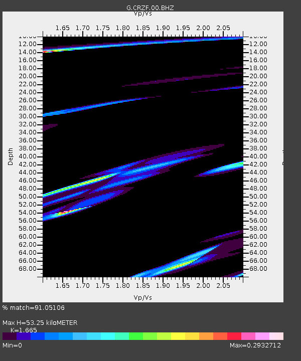
| Estimated Moho Depth: |
53.25 km |
| Estimated Crust Vp/Vs: |
1.66 |
| Assumed Crust Vp: |
4.802 km/s |
| Estimated Crust Vs: |
2.884 km/s |
| Estimated Crust Poisson's Ratio: |
0.22 |
|
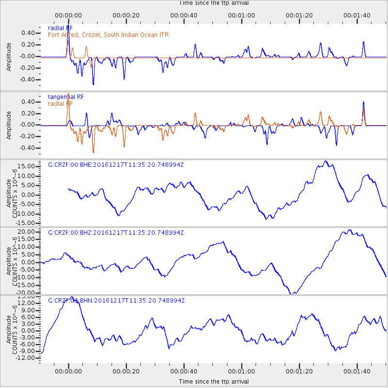
| Radial Match: |
91.05106 % |
| Radial Bump: |
292 |
| Transverse Match: |
75.27011 % |
| Transverse Bump: |
268 |
| SOD ConfigId: |
1894071 |
| Insert Time: |
2016-12-31 11:23:27.766 +0000 |
| GWidth: |
2.5 |
| Max Bumps: |
400 |
| Tol: |
0.001 |
|
Signal To Noise
| Channel | StoN | STA | LTA |
| G:CRZF:00:BHZ:20161217T11:35:20.748994Z | 0.81833047 | 3.0616382E-6 | 3.7413224E-6 |
| G:CRZF:00:BHN:20161217T11:35:20.748994Z | 2.2366343 | 1.6257562E-5 | 7.2687617E-6 |
| G:CRZF:00:BHE:20161217T11:35:20.748994Z | 1.198066 | 4.886936E-6 | 4.079021E-6 |
| Arrivals |
| Ps | 7.5 SECOND |
| PpPs | 29 SECOND |
| PsPs/PpSs | 37 SECOND |


