You are here: Home > Network List > G - GEOSCOPE Stations List
> Station RER Riviere de l'Est, La Reunion (Indian Ocean) > Earthquake Result Viewer
RER Riviere de l'Est, La Reunion (Indian Ocean) - Earthquake Result Viewer
| Earthquake location: |
New Ireland Region, P.N.G. |
| Earthquake latitude/longitude: |
-4.4/153.5 |
| Earthquake time(UTC): |
2016/12/17 (352) 11:22:39 GMT |
| Earthquake Depth: |
83 km |
| Earthquake Magnitude: |
5.6 mb |
| Earthquake Catalog/Contributor: |
NEIC PDE/us |
|
| Network: |
G GEOSCOPE |
| Station: |
RER Riviere de l'Est, La Reunion (Indian Ocean) |
| Lat/Lon: |
21.16 S/55.75 E |
| Elevation: |
834 m |
|
| Distance: |
95.7 deg |
| Az: |
248.327 deg |
| Baz: |
96.93 deg |
| Ray Param: |
0.04066514 |
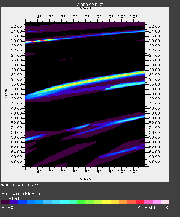
| Estimated Moho Depth: |
18.0 km |
| Estimated Crust Vp/Vs: |
1.61 |
| Assumed Crust Vp: |
4.73 km/s |
| Estimated Crust Vs: |
2.938 km/s |
| Estimated Crust Poisson's Ratio: |
0.19 |
|
| Radial Match: |
92.83765 % |
| Radial Bump: |
400 |
| Transverse Match: |
61.166607 % |
| Transverse Bump: |
400 |
| SOD ConfigId: |
1894071 |
| Insert Time: |
2016-12-31 11:23:31.725 +0000 |
| GWidth: |
2.5 |
| Max Bumps: |
400 |
| Tol: |
0.001 |
|
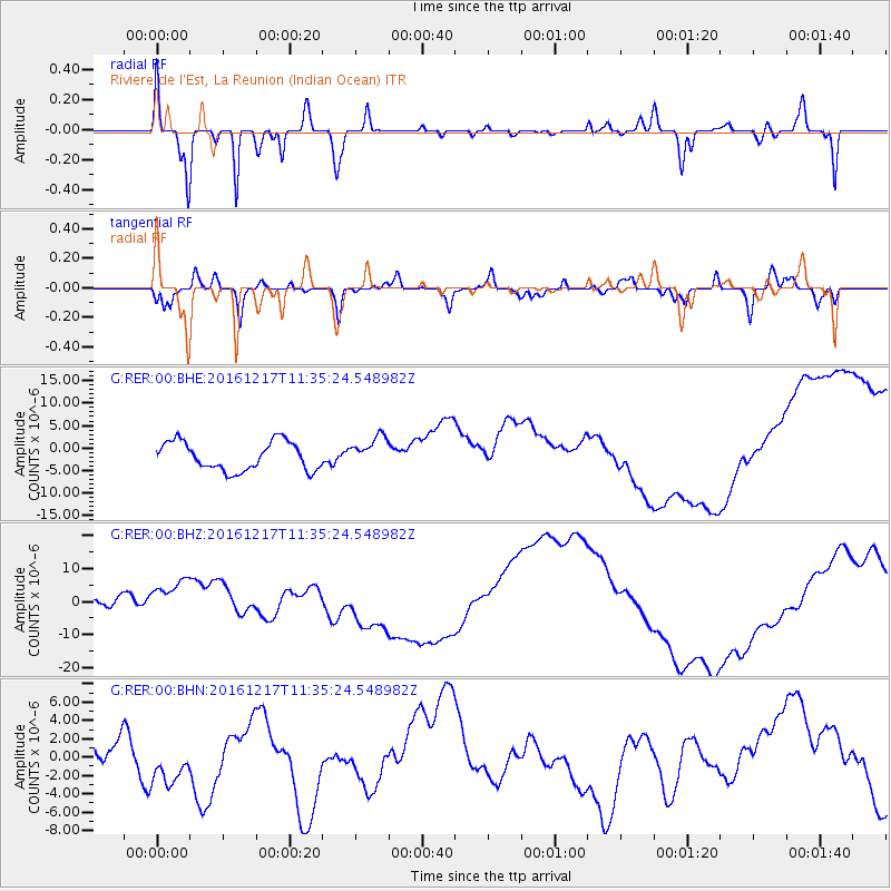
Signal To Noise
| Channel | StoN | STA | LTA |
| G:RER:00:BHZ:20161217T11:35:24.548982Z | 3.6523533 | 6.622027E-6 | 1.813085E-6 |
| G:RER:00:BHN:20161217T11:35:24.548982Z | 1.2394099 | 2.9364007E-6 | 2.3691928E-6 |
| G:RER:00:BHE:20161217T11:35:24.548982Z | 1.0627068 | 3.3590345E-6 | 3.160829E-6 |
| Arrivals |
| Ps | 2.3 SECOND |
| PpPs | 9.8 SECOND |
| PsPs/PpSs | 12 SECOND |


