You are here: Home > Network List > US - United States National Seismic Network Stations List
> Station LAO LASA Array, Montana, USA > Earthquake Result Viewer
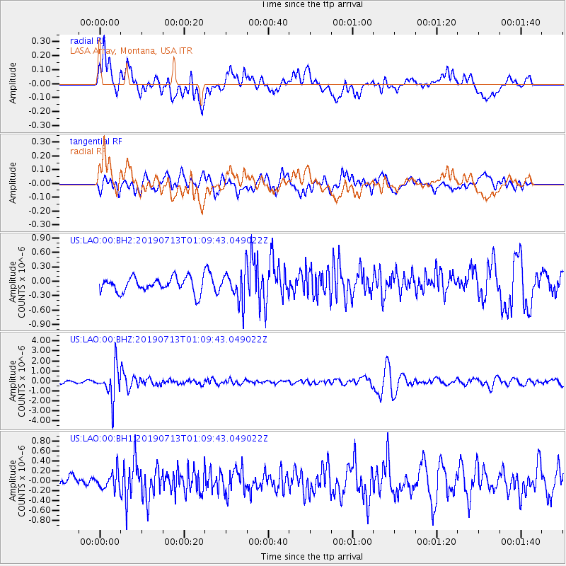
LAO LASA Array, Montana, USA - Earthquake Result Viewer
*The percent match for this event was below the threshold and hence no stack was calculated.
| Earthquake location: |
Northwest Of Ryukyu Islands |
| Earthquake latitude/longitude: |
29.4/128.2 |
| Earthquake time(UTC): |
2019/07/13 (194) 00:57:44 GMT |
| Earthquake Depth: |
251 km |
| Earthquake Magnitude: |
6.1 Mww |
| Earthquake Catalog/Contributor: |
NEIC PDE/us |
|
| Network: |
US United States National Seismic Network |
| Station: |
LAO LASA Array, Montana, USA |
| Lat/Lon: |
46.69 N/106.22 W |
| Elevation: |
902 m |
|
| Distance: |
89.8 deg |
| Az: |
34.027 deg |
| Baz: |
314.794 deg |
| Ray Param: |
$rayparam |
*The percent match for this event was below the threshold and hence was not used in the summary stack. |
|
| Radial Match: |
70.76771 % |
| Radial Bump: |
400 |
| Transverse Match: |
67.17476 % |
| Transverse Bump: |
400 |
| SOD ConfigId: |
19053131 |
| Insert Time: |
2019-07-27 01:08:10.758 +0000 |
| GWidth: |
2.5 |
| Max Bumps: |
400 |
| Tol: |
0.001 |
|
Signal To Noise
| Channel | StoN | STA | LTA |
| US:LAO:00:BHZ:20190713T01:09:43.049022Z | 20.47996 | 1.623577E-6 | 7.9276376E-8 |
| US:LAO:00:BH1:20190713T01:09:43.049022Z | 1.4496909 | 1.7643373E-7 | 1.2170437E-7 |
| US:LAO:00:BH2:20190713T01:09:43.049022Z | 2.1619444 | 3.2939064E-7 | 1.5235851E-7 |
| Arrivals |
| Ps | |
| PpPs | |
| PsPs/PpSs | |


