You are here: Home > Network List > UU - University of Utah Regional Network Stations List
> Station TCU Toone Canyon, UT, USA > Earthquake Result Viewer
TCU Toone Canyon, UT, USA - Earthquake Result Viewer
| Earthquake location: |
Northwest Of Ryukyu Islands |
| Earthquake latitude/longitude: |
29.4/128.2 |
| Earthquake time(UTC): |
2019/07/13 (194) 00:57:44 GMT |
| Earthquake Depth: |
251 km |
| Earthquake Magnitude: |
6.1 Mww |
| Earthquake Catalog/Contributor: |
NEIC PDE/us |
|
| Network: |
UU University of Utah Regional Network |
| Station: |
TCU Toone Canyon, UT, USA |
| Lat/Lon: |
41.12 N/111.41 W |
| Elevation: |
2269 m |
|
| Distance: |
90.8 deg |
| Az: |
40.653 deg |
| Baz: |
311.169 deg |
| Ray Param: |
0.04157943 |
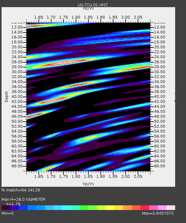
| Estimated Moho Depth: |
26.0 km |
| Estimated Crust Vp/Vs: |
1.76 |
| Assumed Crust Vp: |
6.155 km/s |
| Estimated Crust Vs: |
3.497 km/s |
| Estimated Crust Poisson's Ratio: |
0.26 |
|
| Radial Match: |
84.34129 % |
| Radial Bump: |
400 |
| Transverse Match: |
83.08163 % |
| Transverse Bump: |
400 |
| SOD ConfigId: |
19053131 |
| Insert Time: |
2019-07-27 01:08:31.590 +0000 |
| GWidth: |
2.5 |
| Max Bumps: |
400 |
| Tol: |
0.001 |
|

Signal To Noise
| Channel | StoN | STA | LTA |
| UU:TCU:01:HHZ:20190713T01:09:47.89503Z | 12.862689 | 3.3639335E-8 | 2.6152647E-9 |
| UU:TCU:01:HHN:20190713T01:09:47.89503Z | 5.948778 | 1.1270666E-8 | 1.8946187E-9 |
| UU:TCU:01:HHE:20190713T01:09:47.89503Z | 2.4883852 | 8.500863E-9 | 3.4162166E-9 |
| Arrivals |
| Ps | 3.3 SECOND |
| PpPs | 11 SECOND |
| PsPs/PpSs | 15 SECOND |


