You are here: Home > Network List > UW - Pacific Northwest Regional Seismic Network Stations List
> Station LEBA Lebam, WA, USA > Earthquake Result Viewer
LEBA Lebam, WA, USA - Earthquake Result Viewer
*The percent match for this event was below the threshold and hence no stack was calculated.
| Earthquake location: |
Northwest Of Ryukyu Islands |
| Earthquake latitude/longitude: |
29.4/128.2 |
| Earthquake time(UTC): |
2019/07/13 (194) 00:57:44 GMT |
| Earthquake Depth: |
251 km |
| Earthquake Magnitude: |
6.1 Mww |
| Earthquake Catalog/Contributor: |
NEIC PDE/us |
|
| Network: |
UW Pacific Northwest Regional Seismic Network |
| Station: |
LEBA Lebam, WA, USA |
| Lat/Lon: |
46.55 N/123.56 W |
| Elevation: |
73 m |
|
| Distance: |
80.6 deg |
| Az: |
41.632 deg |
| Baz: |
302.828 deg |
| Ray Param: |
$rayparam |
*The percent match for this event was below the threshold and hence was not used in the summary stack. |
|
| Radial Match: |
67.92842 % |
| Radial Bump: |
400 |
| Transverse Match: |
63.58797 % |
| Transverse Bump: |
400 |
| SOD ConfigId: |
19053131 |
| Insert Time: |
2019-07-27 01:08:45.513 +0000 |
| GWidth: |
2.5 |
| Max Bumps: |
400 |
| Tol: |
0.001 |
|
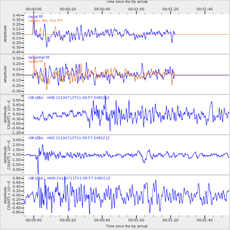
Signal To Noise
| Channel | StoN | STA | LTA |
| UW:LEBA: :HHZ:20190713T01:08:57.648021Z | 11.527568 | 1.0530922E-6 | 9.135424E-8 |
| UW:LEBA: :HHN:20190713T01:08:57.648021Z | 1.8141074 | 3.0030847E-7 | 1.6554063E-7 |
| UW:LEBA: :HHE:20190713T01:08:57.648021Z | 2.088772 | 3.21762E-7 | 1.5404362E-7 |
| Arrivals |
| Ps | |
| PpPs | |
| PsPs/PpSs | |


