You are here: Home > Network List > US - United States National Seismic Network Stations List
> Station AHID Auburn Hatchery, Idaho, USA > Earthquake Result Viewer
AHID Auburn Hatchery, Idaho, USA - Earthquake Result Viewer
| Earthquake location: |
New Ireland Region, P.N.G. |
| Earthquake latitude/longitude: |
-4.4/153.5 |
| Earthquake time(UTC): |
2016/12/17 (352) 11:22:39 GMT |
| Earthquake Depth: |
83 km |
| Earthquake Magnitude: |
5.6 mb |
| Earthquake Catalog/Contributor: |
NEIC PDE/us |
|
| Network: |
US United States National Seismic Network |
| Station: |
AHID Auburn Hatchery, Idaho, USA |
| Lat/Lon: |
42.77 N/111.10 W |
| Elevation: |
1960 m |
|
| Distance: |
96.9 deg |
| Az: |
47.609 deg |
| Baz: |
270.378 deg |
| Ray Param: |
0.040308334 |
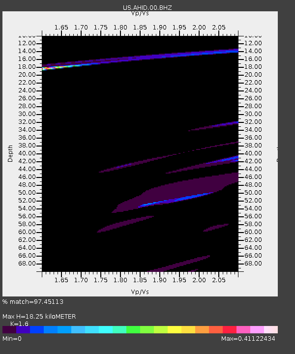
| Estimated Moho Depth: |
18.25 km |
| Estimated Crust Vp/Vs: |
1.60 |
| Assumed Crust Vp: |
6.207 km/s |
| Estimated Crust Vs: |
3.879 km/s |
| Estimated Crust Poisson's Ratio: |
0.18 |
|
| Radial Match: |
97.45113 % |
| Radial Bump: |
301 |
| Transverse Match: |
89.55949 % |
| Transverse Bump: |
400 |
| SOD ConfigId: |
1894071 |
| Insert Time: |
2016-12-31 11:24:27.031 +0000 |
| GWidth: |
2.5 |
| Max Bumps: |
400 |
| Tol: |
0.001 |
|

Signal To Noise
| Channel | StoN | STA | LTA |
| US:AHID:00:BHZ:20161217T11:35:30.123994Z | 2.4282715 | 1.2235781E-5 | 5.0388844E-6 |
| US:AHID:00:BH1:20161217T11:35:30.123994Z | 1.0297323 | 5.480497E-6 | 5.322254E-6 |
| US:AHID:00:BH2:20161217T11:35:30.123994Z | 1.1052732 | 7.4843256E-6 | 6.771471E-6 |
| Arrivals |
| Ps | 1.8 SECOND |
| PpPs | 7.5 SECOND |
| PsPs/PpSs | 9.3 SECOND |


