You are here: Home > Network List > XV14 - Fault Locations and Alaska Tectonics from Seismicity Stations List
> Station F7TV Tanana River 7, Tolovana, AK, USA > Earthquake Result Viewer
F7TV Tanana River 7, Tolovana, AK, USA - Earthquake Result Viewer
| Earthquake location: |
Northwest Of Ryukyu Islands |
| Earthquake latitude/longitude: |
29.4/128.2 |
| Earthquake time(UTC): |
2019/07/13 (194) 00:57:44 GMT |
| Earthquake Depth: |
251 km |
| Earthquake Magnitude: |
6.1 Mww |
| Earthquake Catalog/Contributor: |
NEIC PDE/us |
|
| Network: |
XV Fault Locations and Alaska Tectonics from Seismicity |
| Station: |
F7TV Tanana River 7, Tolovana, AK, USA |
| Lat/Lon: |
64.85 N/149.83 W |
| Elevation: |
94 m |
|
| Distance: |
60.5 deg |
| Az: |
29.095 deg |
| Baz: |
276.52 deg |
| Ray Param: |
0.060680203 |
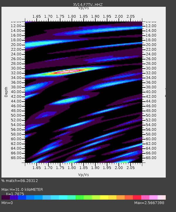
| Estimated Moho Depth: |
31.0 km |
| Estimated Crust Vp/Vs: |
1.79 |
| Assumed Crust Vp: |
6.566 km/s |
| Estimated Crust Vs: |
3.673 km/s |
| Estimated Crust Poisson's Ratio: |
0.27 |
|
| Radial Match: |
86.28312 % |
| Radial Bump: |
400 |
| Transverse Match: |
78.23373 % |
| Transverse Bump: |
400 |
| SOD ConfigId: |
19053131 |
| Insert Time: |
2019-07-27 01:09:19.503 +0000 |
| GWidth: |
2.5 |
| Max Bumps: |
400 |
| Tol: |
0.001 |
|

Signal To Noise
| Channel | StoN | STA | LTA |
| XV:F7TV: :HHZ:20190713T01:06:57.029979Z | 41.162083 | 3.928202E-6 | 9.543253E-8 |
| XV:F7TV: :HHN:20190713T01:06:57.029979Z | 15.608281 | 2.6403306E-6 | 1.6916216E-7 |
| XV:F7TV: :HHE:20190713T01:06:57.029979Z | 19.517899 | 3.576163E-6 | 1.8322478E-7 |
| Arrivals |
| Ps | 3.9 SECOND |
| PpPs | 13 SECOND |
| PsPs/PpSs | 16 SECOND |


