You are here: Home > Network List > GM - US Geological Survey Networks Stations List
> Station IWM01 Jericho 2M Well Monitoring Station > Earthquake Result Viewer
IWM01 Jericho 2M Well Monitoring Station - Earthquake Result Viewer
*The percent match for this event was below the threshold and hence no stack was calculated.
| Earthquake location: |
Southern East Pacific Rise |
| Earthquake latitude/longitude: |
-49.6/-116.6 |
| Earthquake time(UTC): |
2019/07/13 (194) 07:59:35 GMT |
| Earthquake Depth: |
10 km |
| Earthquake Magnitude: |
5.6 Mww |
| Earthquake Catalog/Contributor: |
NEIC PDE/us |
|
| Network: |
GM US Geological Survey Networks |
| Station: |
IWM01 Jericho 2M Well Monitoring Station |
| Lat/Lon: |
36.73 N/96.53 W |
| Elevation: |
328 m |
|
| Distance: |
87.8 deg |
| Az: |
15.988 deg |
| Baz: |
192.89 deg |
| Ray Param: |
$rayparam |
*The percent match for this event was below the threshold and hence was not used in the summary stack. |
|
| Radial Match: |
42.668835 % |
| Radial Bump: |
400 |
| Transverse Match: |
43.519085 % |
| Transverse Bump: |
400 |
| SOD ConfigId: |
19053131 |
| Insert Time: |
2019-07-27 08:02:38.544 +0000 |
| GWidth: |
2.5 |
| Max Bumps: |
400 |
| Tol: |
0.001 |
|
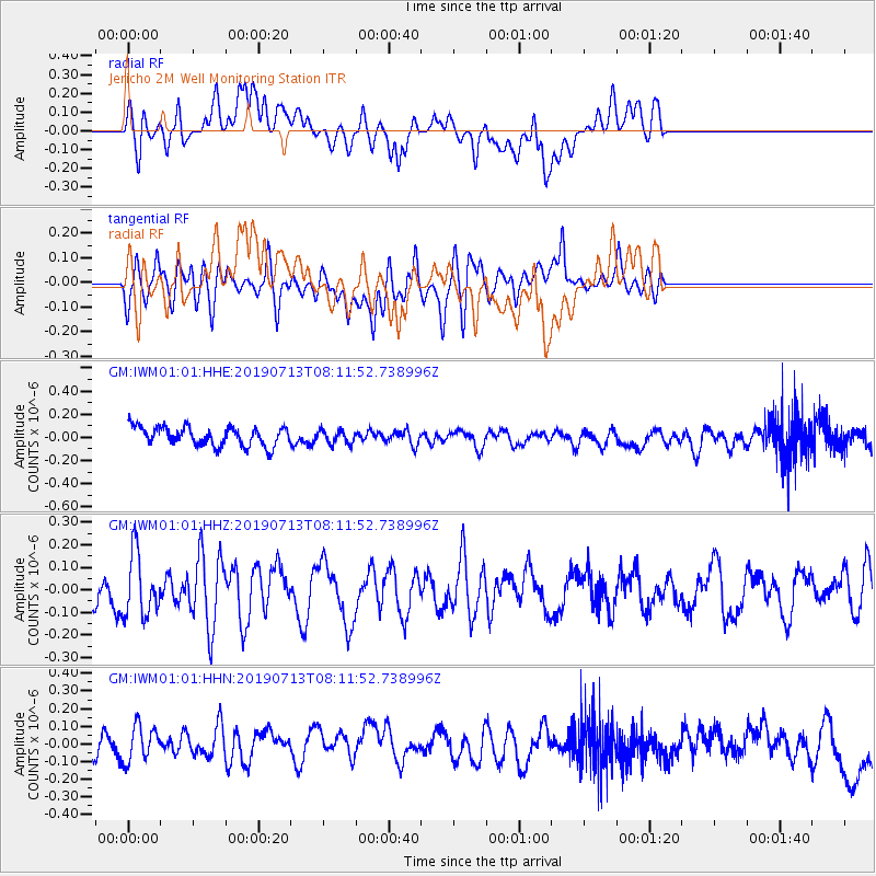
Signal To Noise
| Channel | StoN | STA | LTA |
| GM:IWM01:01:HHZ:20190713T08:11:52.738996Z | 1.1211271 | 1.380382E-7 | 1.2312448E-7 |
| GM:IWM01:01:HHN:20190713T08:11:52.738996Z | 1.2762095 | 1.2549354E-7 | 9.8333025E-8 |
| GM:IWM01:01:HHE:20190713T08:11:52.738996Z | 0.7134075 | 5.816869E-8 | 8.153641E-8 |
| Arrivals |
| Ps | |
| PpPs | |
| PsPs/PpSs | |


