You are here: Home > Network List > US - United States National Seismic Network Stations List
> Station WUAZ Wupatki, Arizona, USA > Earthquake Result Viewer
WUAZ Wupatki, Arizona, USA - Earthquake Result Viewer

| Earthquake location: |
New Ireland Region, P.N.G. |
| Earthquake latitude/longitude: |
-4.4/153.5 |
| Earthquake time(UTC): |
2016/12/17 (352) 11:22:39 GMT |
| Earthquake Depth: |
83 km |
| Earthquake Magnitude: |
5.6 mb |
| Earthquake Catalog/Contributor: |
NEIC PDE/us |
|
| Network: |
US United States National Seismic Network |
| Station: |
WUAZ Wupatki, Arizona, USA |
| Lat/Lon: |
35.52 N/111.37 W |
| Elevation: |
1592 m |
|
| Distance: |
96.7 deg |
| Az: |
54.899 deg |
| Baz: |
269.342 deg |
| Ray Param: |
0.040377833 |
| Estimated Moho Depth: |
14.75 km |
| Estimated Crust Vp/Vs: |
1.62 |
| Assumed Crust Vp: |
6.207 km/s |
| Estimated Crust Vs: |
3.831 km/s |
| Estimated Crust Poisson's Ratio: |
0.19 |
|
| Radial Match: |
96.8728 % |
| Radial Bump: |
387 |
| Transverse Match: |
31.527359 % |
| Transverse Bump: |
370 |
| SOD ConfigId: |
1894071 |
| Insert Time: |
2016-12-31 11:24:40.494 +0000 |
| GWidth: |
2.5 |
| Max Bumps: |
400 |
| Tol: |
0.001 |
|
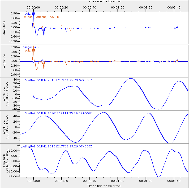
Signal To Noise
| Channel | StoN | STA | LTA |
| US:WUAZ:00:BHZ:20161217T11:35:29.074006Z | 2.6679075 | 3.5666144E-5 | 1.33685835E-5 |
| US:WUAZ:00:BH1:20161217T11:35:29.074006Z | 0.64519894 | 6.5650743E-6 | 1.0175271E-5 |
| US:WUAZ:00:BH2:20161217T11:35:29.074006Z | 1.7310812 | 2.0766E-5 | 1.199597E-5 |
| Arrivals |
| Ps | 1.5 SECOND |
| PpPs | 6.1 SECOND |
| PsPs/PpSs | 7.6 SECOND |


