You are here: Home > Network List > UU - University of Utah Regional Network Stations List
> Station HVU Hansel Valley, UT, USA > Earthquake Result Viewer
HVU Hansel Valley, UT, USA - Earthquake Result Viewer
| Earthquake location: |
New Ireland Region, P.N.G. |
| Earthquake latitude/longitude: |
-4.4/153.5 |
| Earthquake time(UTC): |
2016/12/17 (352) 11:22:39 GMT |
| Earthquake Depth: |
83 km |
| Earthquake Magnitude: |
5.6 mb |
| Earthquake Catalog/Contributor: |
NEIC PDE/us |
|
| Network: |
UU University of Utah Regional Network |
| Station: |
HVU Hansel Valley, UT, USA |
| Lat/Lon: |
41.78 N/112.78 W |
| Elevation: |
1609 m |
|
| Distance: |
95.7 deg |
| Az: |
48.595 deg |
| Baz: |
269.148 deg |
| Ray Param: |
0.040664665 |
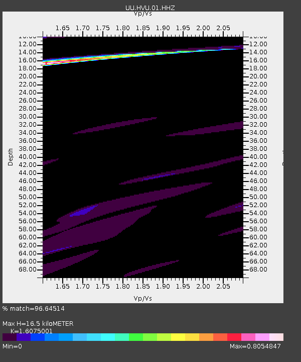
| Estimated Moho Depth: |
16.5 km |
| Estimated Crust Vp/Vs: |
1.61 |
| Assumed Crust Vp: |
6.276 km/s |
| Estimated Crust Vs: |
3.904 km/s |
| Estimated Crust Poisson's Ratio: |
0.18 |
|
| Radial Match: |
96.64514 % |
| Radial Bump: |
400 |
| Transverse Match: |
81.95085 % |
| Transverse Bump: |
400 |
| SOD ConfigId: |
1894071 |
| Insert Time: |
2016-12-31 11:24:52.937 +0000 |
| GWidth: |
2.5 |
| Max Bumps: |
400 |
| Tol: |
0.001 |
|
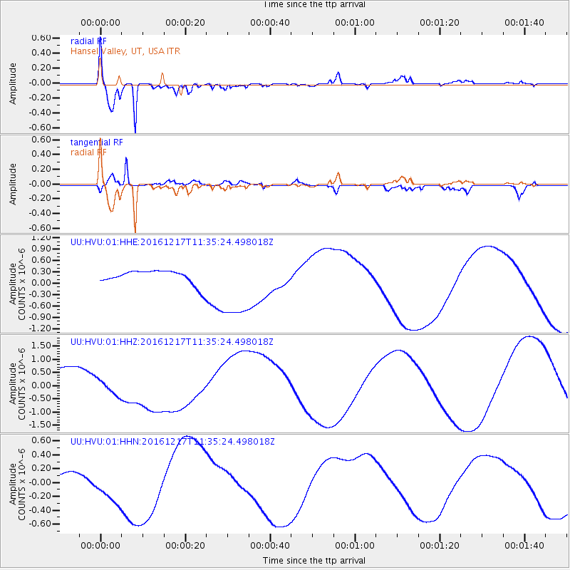
Signal To Noise
| Channel | StoN | STA | LTA |
| UU:HVU:01:HHZ:20161217T11:35:24.498018Z | 0.7034475 | 3.489293E-7 | 4.9602744E-7 |
| UU:HVU:01:HHN:20161217T11:35:24.498018Z | 4.2433796 | 3.0311622E-7 | 7.143274E-8 |
| UU:HVU:01:HHE:20161217T11:35:24.498018Z | 4.973423 | 9.4429726E-7 | 1.8986867E-7 |
| Arrivals |
| Ps | 1.6 SECOND |
| PpPs | 6.7 SECOND |
| PsPs/PpSs | 8.3 SECOND |


