You are here: Home > Network List > PF - Volcanologic Network of Piton de Fournaise-OVPF Stations List
> Station GPS Grandes Pentes Sud > Earthquake Result Viewer
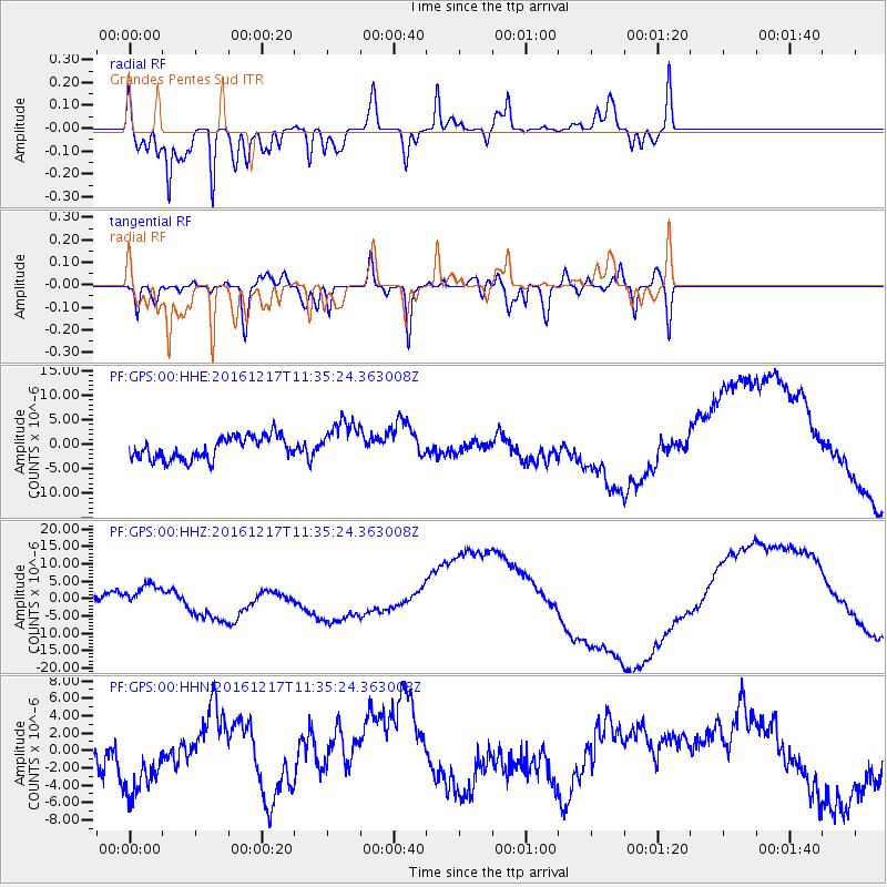
GPS Grandes Pentes Sud - Earthquake Result Viewer
*The percent match for this event was below the threshold and hence no stack was calculated.
| Earthquake location: |
New Ireland Region, P.N.G. |
| Earthquake latitude/longitude: |
-4.4/153.5 |
| Earthquake time(UTC): |
2016/12/17 (352) 11:22:39 GMT |
| Earthquake Depth: |
83 km |
| Earthquake Magnitude: |
5.6 mb |
| Earthquake Catalog/Contributor: |
NEIC PDE/us |
|
| Network: |
PF Volcanologic Network of Piton de Fournaise-OVPF |
| Station: |
GPS Grandes Pentes Sud |
| Lat/Lon: |
21.27 S/55.76 E |
| Elevation: |
1004 m |
|
| Distance: |
95.6 deg |
| Az: |
248.221 deg |
| Baz: |
96.934 deg |
| Ray Param: |
$rayparam |
*The percent match for this event was below the threshold and hence was not used in the summary stack. |
|
| Radial Match: |
92.67124 % |
| Radial Bump: |
338 |
| Transverse Match: |
60.022938 % |
| Transverse Bump: |
400 |
| SOD ConfigId: |
1894071 |
| Insert Time: |
2016-12-31 11:25:46.049 +0000 |
| GWidth: |
2.5 |
| Max Bumps: |
400 |
| Tol: |
0.001 |
|
Signal To Noise
| Channel | StoN | STA | LTA |
| PF:GPS:00:HHZ:20161217T11:35:24.363008Z | 1.4420273 | 2.6878233E-6 | 1.8639198E-6 |
| PF:GPS:00:HHN:20161217T11:35:24.363008Z | 1.7675552 | 4.4554154E-6 | 2.5206652E-6 |
| PF:GPS:00:HHE:20161217T11:35:24.363008Z | 1.8763471 | 4.317026E-6 | 2.300761E-6 |
| Arrivals |
| Ps | |
| PpPs | |
| PsPs/PpSs | |


