You are here: Home > Network List > TA - USArray Transportable Network (new EarthScope stations) Stations List
> Station N12A Clover Valley, Wells, NV, USA > Earthquake Result Viewer
N12A Clover Valley, Wells, NV, USA - Earthquake Result Viewer
| Earthquake location: |
Andreanof Islands, Aleutian Is. |
| Earthquake latitude/longitude: |
51.4/-179.0 |
| Earthquake time(UTC): |
2007/12/21 (355) 07:24:34 GMT |
| Earthquake Depth: |
30 km |
| Earthquake Magnitude: |
6.1 MB, 6.2 MW, 6.3 ML |
| Earthquake Catalog/Contributor: |
WHDF/NEIC |
|
| Network: |
TA USArray Transportable Network (new EarthScope stations) |
| Station: |
N12A Clover Valley, Wells, NV, USA |
| Lat/Lon: |
40.85 N/115.04 W |
| Elevation: |
1786 m |
|
| Distance: |
44.2 deg |
| Az: |
77.673 deg |
| Baz: |
306.148 deg |
| Ray Param: |
0.07199076 |
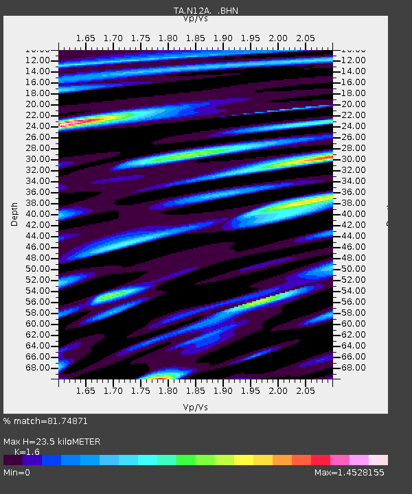
| Estimated Moho Depth: |
23.5 km |
| Estimated Crust Vp/Vs: |
1.60 |
| Assumed Crust Vp: |
6.276 km/s |
| Estimated Crust Vs: |
3.922 km/s |
| Estimated Crust Poisson's Ratio: |
0.18 |
|
| Radial Match: |
81.74871 % |
| Radial Bump: |
400 |
| Transverse Match: |
75.434044 % |
| Transverse Bump: |
400 |
| SOD ConfigId: |
2564 |
| Insert Time: |
2010-03-07 01:45:25.442 +0000 |
| GWidth: |
2.5 |
| Max Bumps: |
400 |
| Tol: |
0.001 |
|
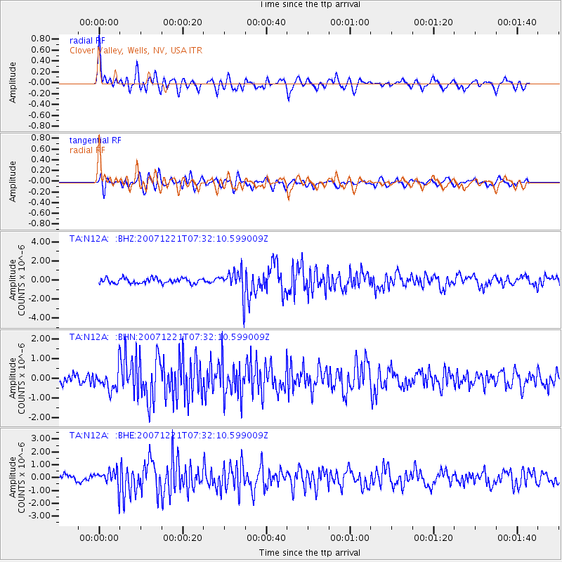
Signal To Noise
| Channel | StoN | STA | LTA |
| TA:N12A: :BHN:20071221T07:32:10.599009Z | 1.8707062 | 5.5719175E-7 | 2.9785102E-7 |
| TA:N12A: :BHE:20071221T07:32:10.599009Z | 2.2051532 | 6.882265E-7 | 3.120992E-7 |
| TA:N12A: :BHZ:20071221T07:32:10.599009Z | 5.0928116 | 1.372288E-6 | 2.6945588E-7 |
| Arrivals |
| Ps | 2.4 SECOND |
| PpPs | 9.1 SECOND |
| PsPs/PpSs | 11 SECOND |


