You are here: Home > Network List > TA - USArray Transportable Network (new EarthScope stations) Stations List
> Station N12A Clover Valley, Wells, NV, USA > Earthquake Result Viewer
N12A Clover Valley, Wells, NV, USA - Earthquake Result Viewer
| Earthquake location: |
Andreanof Islands, Aleutian Is. |
| Earthquake latitude/longitude: |
51.3/-179.5 |
| Earthquake time(UTC): |
2007/12/19 (353) 10:24:33 GMT |
| Earthquake Depth: |
30 km |
| Earthquake Magnitude: |
5.5 MB, 5.3 ML |
| Earthquake Catalog/Contributor: |
WHDF/NEIC |
|
| Network: |
TA USArray Transportable Network (new EarthScope stations) |
| Station: |
N12A Clover Valley, Wells, NV, USA |
| Lat/Lon: |
40.85 N/115.04 W |
| Elevation: |
1786 m |
|
| Distance: |
44.5 deg |
| Az: |
77.328 deg |
| Baz: |
306.229 deg |
| Ray Param: |
0.07179426 |
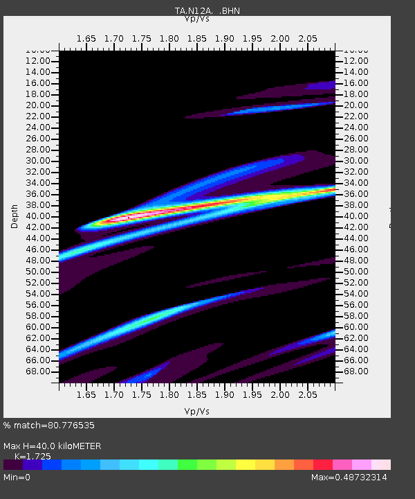
| Estimated Moho Depth: |
40.0 km |
| Estimated Crust Vp/Vs: |
1.73 |
| Assumed Crust Vp: |
6.276 km/s |
| Estimated Crust Vs: |
3.638 km/s |
| Estimated Crust Poisson's Ratio: |
0.25 |
|
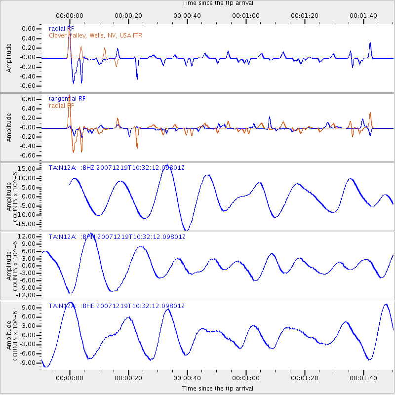
| Radial Match: |
80.776535 % |
| Radial Bump: |
400 |
| Transverse Match: |
65.193954 % |
| Transverse Bump: |
377 |
| SOD ConfigId: |
2564 |
| Insert Time: |
2010-03-07 01:45:27.509 +0000 |
| GWidth: |
2.5 |
| Max Bumps: |
400 |
| Tol: |
0.001 |
|
Signal To Noise
| Channel | StoN | STA | LTA |
| TA:N12A: :BHN:20071219T10:32:12.09801Z | 1.5708104 | 8.205753E-6 | 5.223898E-6 |
| TA:N12A: :BHE:20071219T10:32:12.09801Z | 1.8030486 | 9.066049E-6 | 5.028178E-6 |
| TA:N12A: :BHZ:20071219T10:32:12.09801Z | 1.8136873 | 1.2749516E-5 | 7.029611E-6 |
| Arrivals |
| Ps | 4.9 SECOND |
| PpPs | 16 SECOND |
| PsPs/PpSs | 21 SECOND |


