You are here: Home > Network List > TA - USArray Transportable Network (new EarthScope stations) Stations List
> Station N12A Clover Valley, Wells, NV, USA > Earthquake Result Viewer
N12A Clover Valley, Wells, NV, USA - Earthquake Result Viewer
| Earthquake location: |
Solomon Islands |
| Earthquake latitude/longitude: |
-10.9/162.1 |
| Earthquake time(UTC): |
2007/11/27 (331) 11:49:58 GMT |
| Earthquake Depth: |
16 km |
| Earthquake Magnitude: |
5.9 MB, 6.7 MS, 6.6 MW, 6.4 MW |
| Earthquake Catalog/Contributor: |
WHDF/NEIC |
|
| Network: |
TA USArray Transportable Network (new EarthScope stations) |
| Station: |
N12A Clover Valley, Wells, NV, USA |
| Lat/Lon: |
40.85 N/115.04 W |
| Elevation: |
1786 m |
|
| Distance: |
91.7 deg |
| Az: |
48.846 deg |
| Baz: |
257.096 deg |
| Ray Param: |
0.04156713 |
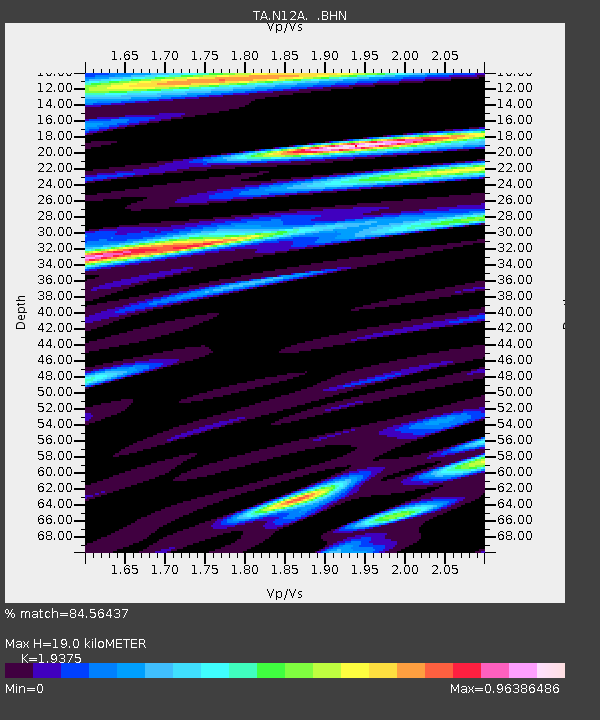
| Estimated Moho Depth: |
19.0 km |
| Estimated Crust Vp/Vs: |
1.94 |
| Assumed Crust Vp: |
6.276 km/s |
| Estimated Crust Vs: |
3.239 km/s |
| Estimated Crust Poisson's Ratio: |
0.32 |
|
| Radial Match: |
84.56437 % |
| Radial Bump: |
400 |
| Transverse Match: |
69.890434 % |
| Transverse Bump: |
400 |
| SOD ConfigId: |
2564 |
| Insert Time: |
2010-03-07 01:45:35.307 +0000 |
| GWidth: |
2.5 |
| Max Bumps: |
400 |
| Tol: |
0.001 |
|
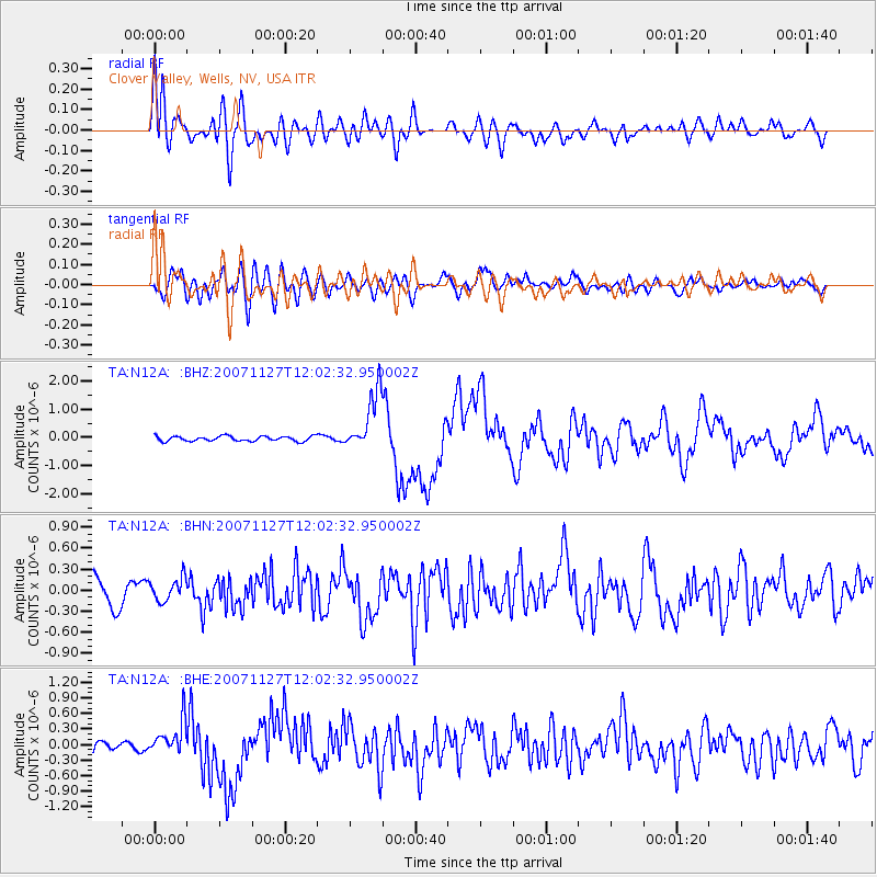
Signal To Noise
| Channel | StoN | STA | LTA |
| TA:N12A: :BHN:20071127T12:02:32.950002Z | 1.0898845 | 1.6233126E-7 | 1.4894354E-7 |
| TA:N12A: :BHE:20071127T12:02:32.950002Z | 2.9069912 | 3.3332503E-7 | 1.14663244E-7 |
| TA:N12A: :BHZ:20071127T12:02:32.950002Z | 11.870218 | 1.0441827E-6 | 8.796659E-8 |
| Arrivals |
| Ps | 2.9 SECOND |
| PpPs | 8.7 SECOND |
| PsPs/PpSs | 12 SECOND |


