You are here: Home > Network List > PF - Volcanologic Network of Piton de Fournaise-OVPF Stations List
> Station PRA Puys Ramond > Earthquake Result Viewer
PRA Puys Ramond - Earthquake Result Viewer
| Earthquake location: |
New Ireland Region, P.N.G. |
| Earthquake latitude/longitude: |
-4.4/153.5 |
| Earthquake time(UTC): |
2016/12/17 (352) 11:22:39 GMT |
| Earthquake Depth: |
83 km |
| Earthquake Magnitude: |
5.6 mb |
| Earthquake Catalog/Contributor: |
NEIC PDE/us |
|
| Network: |
PF Volcanologic Network of Piton de Fournaise-OVPF |
| Station: |
PRA Puys Ramond |
| Lat/Lon: |
21.29 S/55.71 E |
| Elevation: |
2009 m |
|
| Distance: |
95.7 deg |
| Az: |
248.191 deg |
| Baz: |
96.957 deg |
| Ray Param: |
0.04066002 |
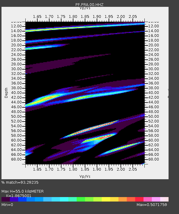
| Estimated Moho Depth: |
55.0 km |
| Estimated Crust Vp/Vs: |
1.87 |
| Assumed Crust Vp: |
4.73 km/s |
| Estimated Crust Vs: |
2.533 km/s |
| Estimated Crust Poisson's Ratio: |
0.30 |
|
| Radial Match: |
93.29235 % |
| Radial Bump: |
400 |
| Transverse Match: |
48.450436 % |
| Transverse Bump: |
400 |
| SOD ConfigId: |
1894071 |
| Insert Time: |
2016-12-31 11:25:56.782 +0000 |
| GWidth: |
2.5 |
| Max Bumps: |
400 |
| Tol: |
0.001 |
|
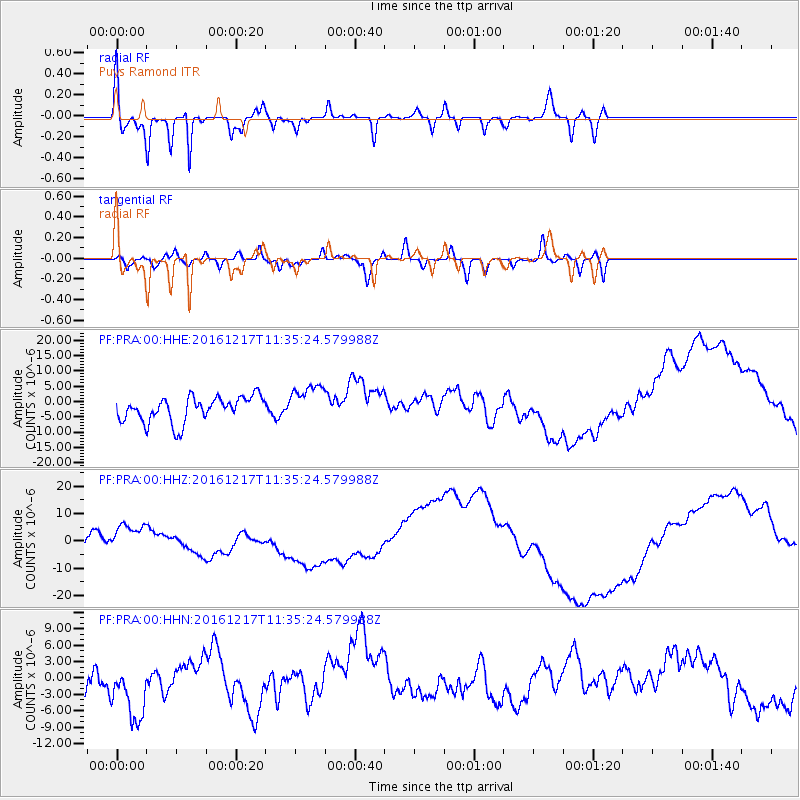
Signal To Noise
| Channel | StoN | STA | LTA |
| PF:PRA:00:HHZ:20161217T11:35:24.579988Z | 1.9419422 | 5.0826893E-6 | 2.6173227E-6 |
| PF:PRA:00:HHN:20161217T11:35:24.579988Z | 2.2056892 | 6.2940676E-6 | 2.8535605E-6 |
| PF:PRA:00:HHE:20161217T11:35:24.579988Z | 1.526724 | 6.1385736E-6 | 4.0207487E-6 |
| Arrivals |
| Ps | 10 SECOND |
| PpPs | 33 SECOND |
| PsPs/PpSs | 43 SECOND |


