You are here: Home > Network List > TA - USArray Transportable Network (new EarthScope stations) Stations List
> Station N12A Clover Valley, Wells, NV, USA > Earthquake Result Viewer
N12A Clover Valley, Wells, NV, USA - Earthquake Result Viewer
| Earthquake location: |
South Of Mariana Islands |
| Earthquake latitude/longitude: |
10.5/145.7 |
| Earthquake time(UTC): |
2007/09/30 (273) 02:08:30 GMT |
| Earthquake Depth: |
14 km |
| Earthquake Magnitude: |
6.4 MB, 7.1 MS, 6.9 MW, 6.9 MW |
| Earthquake Catalog/Contributor: |
WHDF/NEIC |
|
| Network: |
TA USArray Transportable Network (new EarthScope stations) |
| Station: |
N12A Clover Valley, Wells, NV, USA |
| Lat/Lon: |
40.85 N/115.04 W |
| Elevation: |
1786 m |
|
| Distance: |
90.1 deg |
| Az: |
48.48 deg |
| Baz: |
283.869 deg |
| Ray Param: |
0.041694216 |
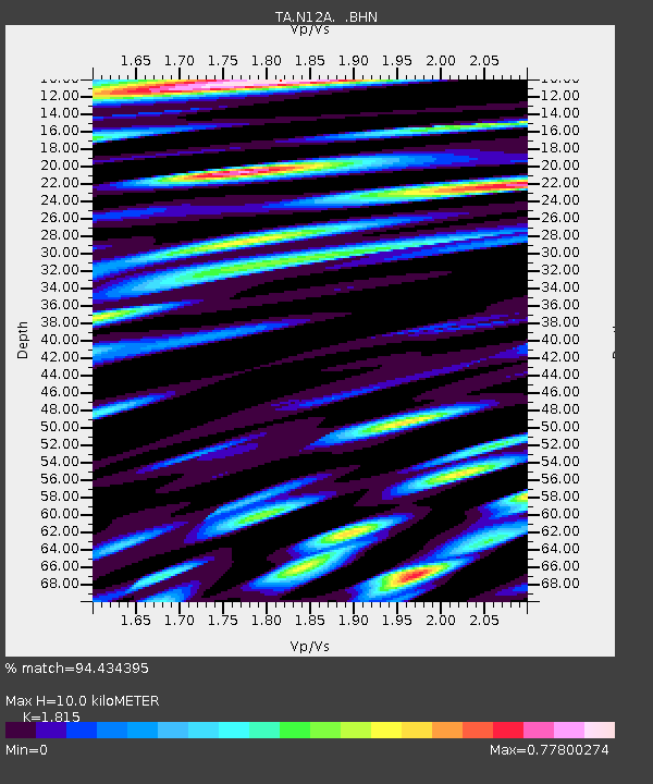
| Estimated Moho Depth: |
10.0 km |
| Estimated Crust Vp/Vs: |
1.82 |
| Assumed Crust Vp: |
6.276 km/s |
| Estimated Crust Vs: |
3.458 km/s |
| Estimated Crust Poisson's Ratio: |
0.28 |
|
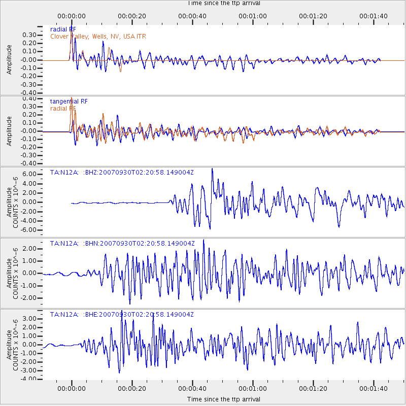
| Radial Match: |
94.434395 % |
| Radial Bump: |
400 |
| Transverse Match: |
92.194824 % |
| Transverse Bump: |
400 |
| SOD ConfigId: |
2564 |
| Insert Time: |
2010-03-07 01:45:49.584 +0000 |
| GWidth: |
2.5 |
| Max Bumps: |
400 |
| Tol: |
0.001 |
|
Signal To Noise
| Channel | StoN | STA | LTA |
| TA:N12A: :BHN:20070930T02:20:58.149004Z | 1.4229298 | 1.1934165E-7 | 8.387037E-8 |
| TA:N12A: :BHE:20070930T02:20:58.149004Z | 1.8434491 | 2.0396155E-7 | 1.1064127E-7 |
| TA:N12A: :BHZ:20070930T02:20:58.149004Z | 7.332193 | 5.659125E-7 | 7.718189E-8 |
| Arrivals |
| Ps | 1.3 SECOND |
| PpPs | 4.4 SECOND |
| PsPs/PpSs | 5.7 SECOND |


