You are here: Home > Network List > TA - USArray Transportable Network (new EarthScope stations) Stations List
> Station N12A Clover Valley, Wells, NV, USA > Earthquake Result Viewer
N12A Clover Valley, Wells, NV, USA - Earthquake Result Viewer
| Earthquake location: |
Santa Cruz Islands |
| Earthquake latitude/longitude: |
-11.6/165.8 |
| Earthquake time(UTC): |
2007/09/02 (245) 01:05:18 GMT |
| Earthquake Depth: |
35 km |
| Earthquake Magnitude: |
5.9 MB, 7.3 MS, 7.2 MW, 6.9 ME |
| Earthquake Catalog/Contributor: |
WHDF/NEIC |
|
| Network: |
TA USArray Transportable Network (new EarthScope stations) |
| Station: |
N12A Clover Valley, Wells, NV, USA |
| Lat/Lon: |
40.85 N/115.04 W |
| Elevation: |
1786 m |
|
| Distance: |
89.5 deg |
| Az: |
48.173 deg |
| Baz: |
254.257 deg |
| Ray Param: |
0.041771427 |
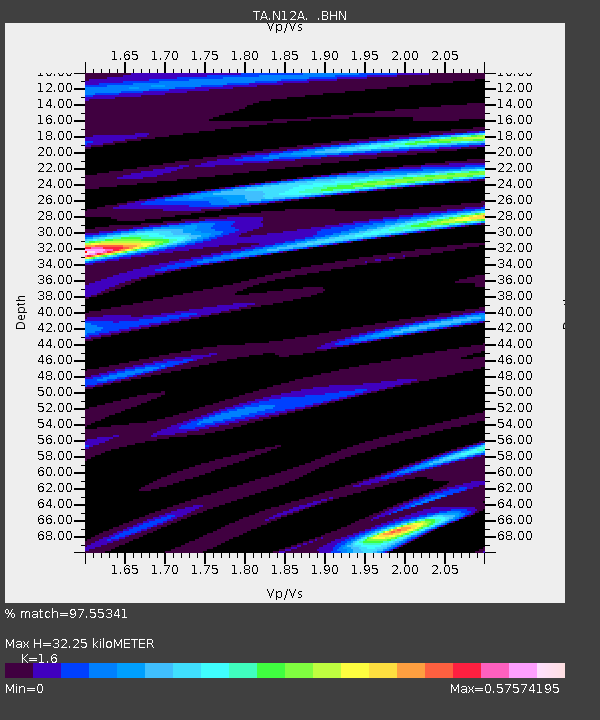
| Estimated Moho Depth: |
32.25 km |
| Estimated Crust Vp/Vs: |
1.60 |
| Assumed Crust Vp: |
6.276 km/s |
| Estimated Crust Vs: |
3.922 km/s |
| Estimated Crust Poisson's Ratio: |
0.18 |
|
| Radial Match: |
97.55341 % |
| Radial Bump: |
400 |
| Transverse Match: |
87.199974 % |
| Transverse Bump: |
400 |
| SOD ConfigId: |
2564 |
| Insert Time: |
2010-03-07 01:45:58.046 +0000 |
| GWidth: |
2.5 |
| Max Bumps: |
400 |
| Tol: |
0.001 |
|
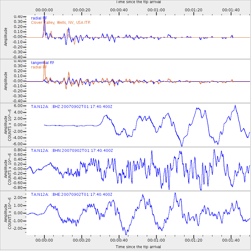
Signal To Noise
| Channel | StoN | STA | LTA |
| TA:N12A: :BHN:20070902T01:17:40.400Z | 2.7969322 | 1.767914E-7 | 6.320904E-8 |
| TA:N12A: :BHE:20070902T01:17:40.400Z | 15.335638 | 8.264664E-7 | 5.389188E-8 |
| TA:N12A: :BHZ:20070902T01:17:40.400Z | 31.760477 | 2.1637093E-6 | 6.812584E-8 |
| Arrivals |
| Ps | 3.2 SECOND |
| PpPs | 13 SECOND |
| PsPs/PpSs | 16 SECOND |


