You are here: Home > Network List > TA - USArray Transportable Network (new EarthScope stations) Stations List
> Station N12A Clover Valley, Wells, NV, USA > Earthquake Result Viewer
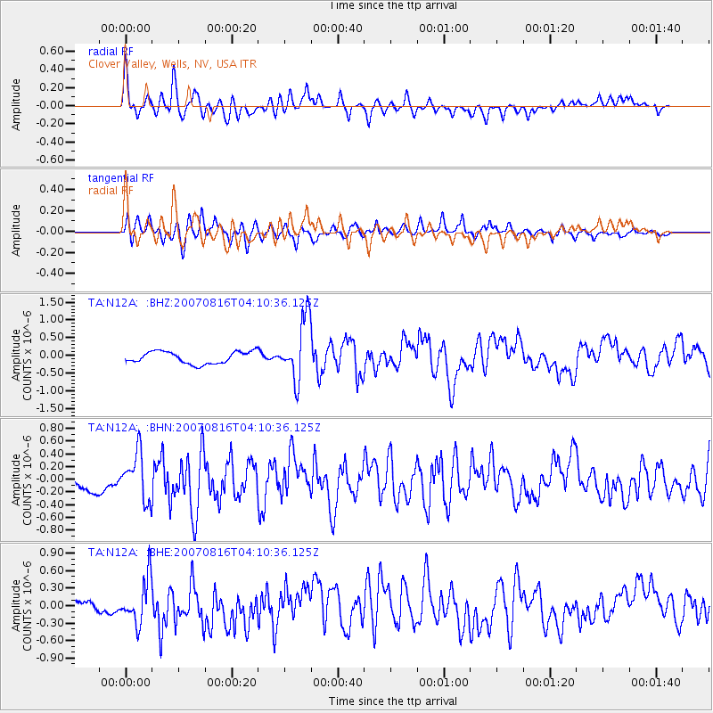
N12A Clover Valley, Wells, NV, USA - Earthquake Result Viewer
| Earthquake location: |
Andreanof Islands, Aleutian Is. |
| Earthquake latitude/longitude: |
50.2/-177.6 |
| Earthquake time(UTC): |
2007/08/16 (228) 04:03:03 GMT |
| Earthquake Depth: |
15 km |
| Earthquake Magnitude: |
5.8 MB |
| Earthquake Catalog/Contributor: |
WHDF/NEIC |
|
| Network: |
TA USArray Transportable Network (new EarthScope stations) |
| Station: |
N12A Clover Valley, Wells, NV, USA |
| Lat/Lon: |
40.85 N/115.04 W |
| Elevation: |
1786 m |
|
| Distance: |
43.6 deg |
| Az: |
77.428 deg |
| Baz: |
304.297 deg |
| Ray Param: |
0.072437696 |
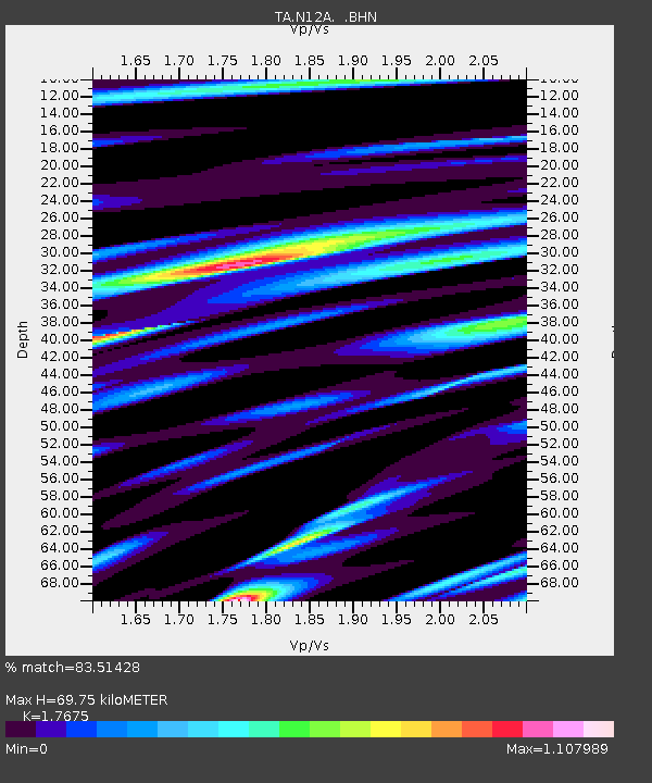
| Estimated Moho Depth: |
69.75 km |
| Estimated Crust Vp/Vs: |
1.77 |
| Assumed Crust Vp: |
6.276 km/s |
| Estimated Crust Vs: |
3.551 km/s |
| Estimated Crust Poisson's Ratio: |
0.26 |
|
| Radial Match: |
83.51428 % |
| Radial Bump: |
400 |
| Transverse Match: |
81.37703 % |
| Transverse Bump: |
400 |
| SOD ConfigId: |
2564 |
| Insert Time: |
2010-03-07 01:46:07.597 +0000 |
| GWidth: |
2.5 |
| Max Bumps: |
400 |
| Tol: |
0.001 |
|
Signal To Noise
| Channel | StoN | STA | LTA |
| TA:N12A: :BHN:20070816T04:10:36.125Z | 2.1570492 | 3.6603444E-7 | 1.6969221E-7 |
| TA:N12A: :BHE:20070816T04:10:36.125Z | 2.8310769 | 3.8400623E-7 | 1.3563964E-7 |
| TA:N12A: :BHZ:20070816T04:10:36.125Z | 5.2511125 | 8.851554E-7 | 1.6856531E-7 |
| Arrivals |
| Ps | 9.1 SECOND |
| PpPs | 29 SECOND |
| PsPs/PpSs | 38 SECOND |


