You are here: Home > Network List > IU - Global Seismograph Network (GSN - IRIS/USGS) Stations List
> Station CTAO Charters Towers, Australia > Earthquake Result Viewer
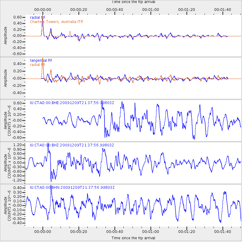
CTAO Charters Towers, Australia - Earthquake Result Viewer
*The percent match for this event was below the threshold and hence no stack was calculated.
| Earthquake location: |
Off W Coast Of Northern Sumatra |
| Earthquake latitude/longitude: |
2.8/95.9 |
| Earthquake time(UTC): |
2009/12/09 (343) 21:29:02 GMT |
| Earthquake Depth: |
19 km |
| Earthquake Magnitude: |
5.7 MB, 5.9 MS, 6.0 MW, 6.0 MW |
| Earthquake Catalog/Contributor: |
WHDF/NEIC |
|
| Network: |
IU Global Seismograph Network (GSN - IRIS/USGS) |
| Station: |
CTAO Charters Towers, Australia |
| Lat/Lon: |
20.09 S/146.25 E |
| Elevation: |
357 m |
|
| Distance: |
54.4 deg |
| Az: |
117.07 deg |
| Baz: |
288.864 deg |
| Ray Param: |
$rayparam |
*The percent match for this event was below the threshold and hence was not used in the summary stack. |
|
| Radial Match: |
69.904564 % |
| Radial Bump: |
349 |
| Transverse Match: |
59.758686 % |
| Transverse Bump: |
400 |
| SOD ConfigId: |
1 |
| Insert Time: |
2010-02-19 01:21:32.576 +0000 |
| GWidth: |
2.5 |
| Max Bumps: |
400 |
| Tol: |
0.001 |
|
Signal To Noise
| Channel | StoN | STA | LTA |
| IU:CTAO:00:BHZ:20091209T21:37:56.99803Z | 3.2466452 | 6.0561825E-7 | 1.8653662E-7 |
| IU:CTAO:00:BHN:20091209T21:37:56.99803Z | 1.2032056 | 1.754628E-7 | 1.4582945E-7 |
| IU:CTAO:00:BHE:20091209T21:37:56.99803Z | 2.85397 | 3.1042273E-7 | 1.0876874E-7 |
| Arrivals |
| Ps | |
| PpPs | |
| PsPs/PpSs | |


