You are here: Home > Network List > TA - USArray Transportable Network (new EarthScope stations) Stations List
> Station N12A Clover Valley, Wells, NV, USA > Earthquake Result Viewer
N12A Clover Valley, Wells, NV, USA - Earthquake Result Viewer

| Earthquake location: |
Central Mid-Atlantic Ridge |
| Earthquake latitude/longitude: |
0.7/-30.3 |
| Earthquake time(UTC): |
2007/07/03 (184) 08:26:00 GMT |
| Earthquake Depth: |
10 km |
| Earthquake Magnitude: |
5.8 MB, 5.9 MS, 6.3 MW, 6.1 MW |
| Earthquake Catalog/Contributor: |
WHDF/NEIC |
|
| Network: |
TA USArray Transportable Network (new EarthScope stations) |
| Station: |
N12A Clover Valley, Wells, NV, USA |
| Lat/Lon: |
40.85 N/115.04 W |
| Elevation: |
1786 m |
|
| Distance: |
85.6 deg |
| Az: |
310.741 deg |
| Baz: |
92.876 deg |
| Ray Param: |
0.04467048 |
| Estimated Moho Depth: |
65.0 km |
| Estimated Crust Vp/Vs: |
1.89 |
| Assumed Crust Vp: |
6.276 km/s |
| Estimated Crust Vs: |
3.312 km/s |
| Estimated Crust Poisson's Ratio: |
0.31 |
|
| Radial Match: |
89.61967 % |
| Radial Bump: |
400 |
| Transverse Match: |
78.12711 % |
| Transverse Bump: |
400 |
| SOD ConfigId: |
2564 |
| Insert Time: |
2010-03-07 01:46:31.784 +0000 |
| GWidth: |
2.5 |
| Max Bumps: |
400 |
| Tol: |
0.001 |
|
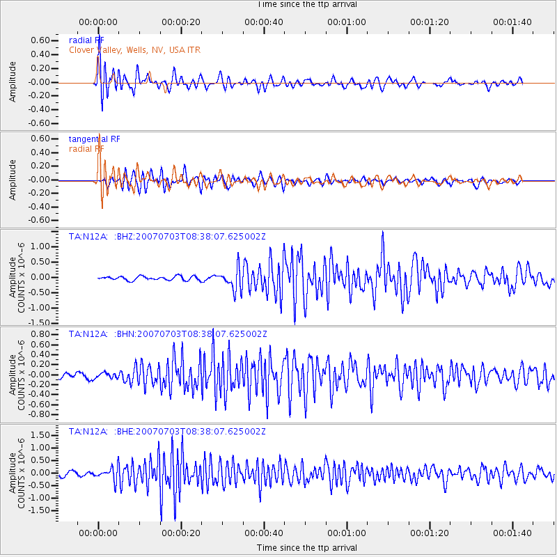
Signal To Noise
| Channel | StoN | STA | LTA |
| TA:N12A: :BHN:20070703T08:38:07.625002Z | 1.3630537 | 5.0392877E-8 | 3.6970576E-8 |
| TA:N12A: :BHE:20070703T08:38:07.625002Z | 2.904885 | 2.627664E-7 | 9.045672E-8 |
| TA:N12A: :BHZ:20070703T08:38:07.625002Z | 5.668607 | 3.574743E-7 | 6.30621E-8 |
| Arrivals |
| Ps | 9.5 SECOND |
| PpPs | 29 SECOND |
| PsPs/PpSs | 39 SECOND |


